You are here: Home > Network List > TA - USArray Transportable Network (new EarthScope stations) Stations List
> Station W56A Indian Trail, NC, USA > Earthquake Result Viewer
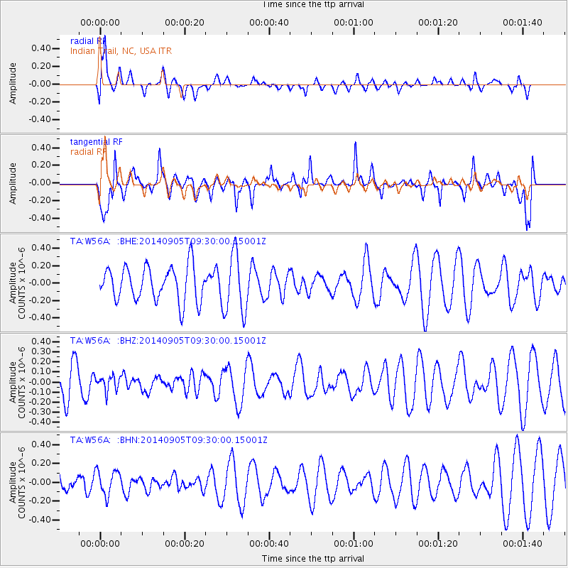
W56A Indian Trail, NC, USA - Earthquake Result Viewer
*The percent match for this event was below the threshold and hence no stack was calculated.
| Earthquake location: |
Easter Island Region |
| Earthquake latitude/longitude: |
-26.7/-114.5 |
| Earthquake time(UTC): |
2014/09/05 (248) 09:19:23 GMT |
| Earthquake Depth: |
10 km |
| Earthquake Magnitude: |
4.9 MW |
| Earthquake Catalog/Contributor: |
ISC/ISC |
|
| Network: |
TA USArray Transportable Network (new EarthScope stations) |
| Station: |
W56A Indian Trail, NC, USA |
| Lat/Lon: |
35.13 N/80.58 W |
| Elevation: |
177 m |
|
| Distance: |
69.3 deg |
| Az: |
29.229 deg |
| Baz: |
212.215 deg |
| Ray Param: |
$rayparam |
*The percent match for this event was below the threshold and hence was not used in the summary stack. |
|
| Radial Match: |
77.434135 % |
| Radial Bump: |
400 |
| Transverse Match: |
67.45295 % |
| Transverse Bump: |
400 |
| SOD ConfigId: |
3390531 |
| Insert Time: |
2019-04-13 21:02:32.827 +0000 |
| GWidth: |
2.5 |
| Max Bumps: |
400 |
| Tol: |
0.001 |
|
Signal To Noise
| Channel | StoN | STA | LTA |
| TA:W56A: :BHZ:20140905T09:30:00.15001Z | 0.5542137 | 7.265453E-8 | 1.310948E-7 |
| TA:W56A: :BHN:20140905T09:30:00.15001Z | 0.98536485 | 1.3191558E-7 | 1.3387488E-7 |
| TA:W56A: :BHE:20140905T09:30:00.15001Z | 1.7795635 | 3.524324E-7 | 1.980443E-7 |
| Arrivals |
| Ps | |
| PpPs | |
| PsPs/PpSs | |


