You are here: Home > Network List > US - United States National Seismic Network Stations List
> Station MNTX Cornudas Mountains, Texas, USA > Earthquake Result Viewer
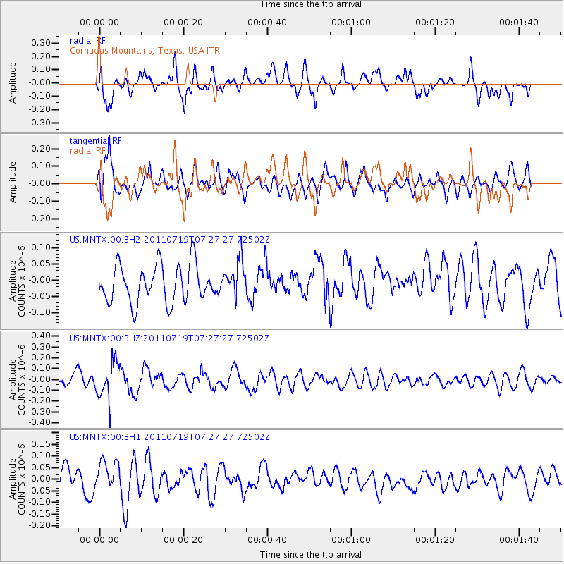
MNTX Cornudas Mountains, Texas, USA - Earthquake Result Viewer
*The percent match for this event was below the threshold and hence no stack was calculated.
| Earthquake location: |
South Of Fiji Islands |
| Earthquake latitude/longitude: |
-23.7/179.0 |
| Earthquake time(UTC): |
2011/07/19 (200) 07:15:55 GMT |
| Earthquake Depth: |
566 km |
| Earthquake Magnitude: |
5.5 MW |
| Earthquake Catalog/Contributor: |
NEIC PDE/NEIC PDE-M |
|
| Network: |
US United States National Seismic Network |
| Station: |
MNTX Cornudas Mountains, Texas, USA |
| Lat/Lon: |
31.70 N/105.38 W |
| Elevation: |
404 m |
|
| Distance: |
90.8 deg |
| Az: |
55.656 deg |
| Baz: |
242.594 deg |
| Ray Param: |
$rayparam |
*The percent match for this event was below the threshold and hence was not used in the summary stack. |
|
| Radial Match: |
63.631992 % |
| Radial Bump: |
400 |
| Transverse Match: |
56.28629 % |
| Transverse Bump: |
400 |
| SOD ConfigId: |
558545 |
| Insert Time: |
2013-09-18 22:55:42.153 +0000 |
| GWidth: |
2.5 |
| Max Bumps: |
400 |
| Tol: |
0.001 |
|
Signal To Noise
| Channel | StoN | STA | LTA |
| US:MNTX:00:BHZ:20110719T07:27:27.72502Z | 3.0017204 | 1.7059753E-7 | 5.6833247E-8 |
| US:MNTX:00:BH1:20110719T07:27:27.72502Z | 1.7670413 | 6.7521206E-8 | 3.8211446E-8 |
| US:MNTX:00:BH2:20110719T07:27:27.72502Z | 0.89799285 | 5.4205355E-8 | 6.036279E-8 |
| Arrivals |
| Ps | |
| PpPs | |
| PsPs/PpSs | |


