You are here: Home > Network List > US - United States National Seismic Network Stations List
> Station DGMT Dagmar, Montana, USA > Earthquake Result Viewer
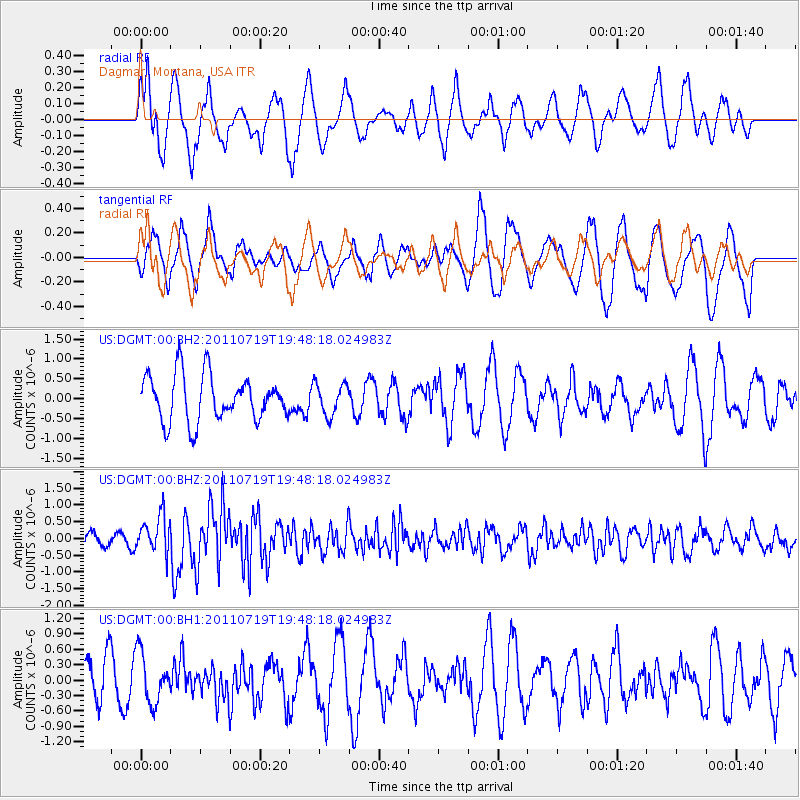
DGMT Dagmar, Montana, USA - Earthquake Result Viewer
*The percent match for this event was below the threshold and hence no stack was calculated.
| Earthquake location: |
Tajikistan |
| Earthquake latitude/longitude: |
40.1/71.4 |
| Earthquake time(UTC): |
2011/07/19 (200) 19:35:43 GMT |
| Earthquake Depth: |
20 km |
| Earthquake Magnitude: |
6.1 MB, 6.2 MS, 6.1 MW, 6.0 MW |
| Earthquake Catalog/Contributor: |
WHDF/NEIC |
|
| Network: |
US United States National Seismic Network |
| Station: |
DGMT Dagmar, Montana, USA |
| Lat/Lon: |
48.47 N/104.20 W |
| Elevation: |
0.0 m |
|
| Distance: |
91.7 deg |
| Az: |
357.075 deg |
| Baz: |
3.372 deg |
| Ray Param: |
$rayparam |
*The percent match for this event was below the threshold and hence was not used in the summary stack. |
|
| Radial Match: |
67.94252 % |
| Radial Bump: |
400 |
| Transverse Match: |
54.4717 % |
| Transverse Bump: |
400 |
| SOD ConfigId: |
558545 |
| Insert Time: |
2013-09-18 22:57:29.649 +0000 |
| GWidth: |
2.5 |
| Max Bumps: |
400 |
| Tol: |
0.001 |
|
Signal To Noise
| Channel | StoN | STA | LTA |
| US:DGMT:00:BHZ:20110719T19:48:18.024983Z | 3.5448768 | 5.58356E-7 | 1.5751071E-7 |
| US:DGMT:00:BH1:20110719T19:48:18.024983Z | 1.2152292 | 4.8069376E-7 | 3.9555812E-7 |
| US:DGMT:00:BH2:20110719T19:48:18.024983Z | 0.68129885 | 3.943175E-7 | 5.7877315E-7 |
| Arrivals |
| Ps | |
| PpPs | |
| PsPs/PpSs | |


