You are here: Home > Network List > IU - Global Seismograph Network (GSN - IRIS/USGS) Stations List
> Station POHA Pohakuloa, Hawaii, USA > Earthquake Result Viewer
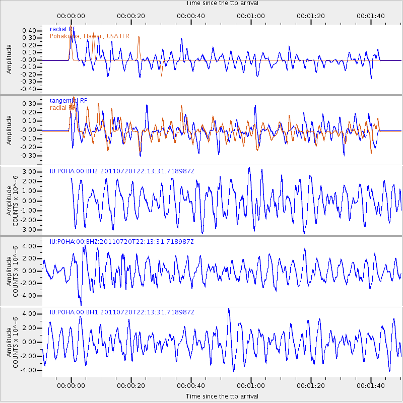
POHA Pohakuloa, Hawaii, USA - Earthquake Result Viewer
*The percent match for this event was below the threshold and hence no stack was calculated.
| Earthquake location: |
Solomon Islands |
| Earthquake latitude/longitude: |
-10.3/162.0 |
| Earthquake time(UTC): |
2011/07/20 (201) 22:04:59 GMT |
| Earthquake Depth: |
21 km |
| Earthquake Magnitude: |
5.9 MB, 5.6 MS, 6.0 MW, 6.0 MW |
| Earthquake Catalog/Contributor: |
WHDF/NEIC |
|
| Network: |
IU Global Seismograph Network (GSN - IRIS/USGS) |
| Station: |
POHA Pohakuloa, Hawaii, USA |
| Lat/Lon: |
19.76 N/155.53 W |
| Elevation: |
1990 m |
|
| Distance: |
51.4 deg |
| Az: |
54.437 deg |
| Baz: |
238.196 deg |
| Ray Param: |
$rayparam |
*The percent match for this event was below the threshold and hence was not used in the summary stack. |
|
| Radial Match: |
70.56996 % |
| Radial Bump: |
400 |
| Transverse Match: |
58.485733 % |
| Transverse Bump: |
400 |
| SOD ConfigId: |
558545 |
| Insert Time: |
2013-09-18 22:59:13.590 +0000 |
| GWidth: |
2.5 |
| Max Bumps: |
400 |
| Tol: |
0.001 |
|
Signal To Noise
| Channel | StoN | STA | LTA |
| IU:POHA:00:BHZ:20110720T22:13:31.718987Z | 2.373306 | 2.900577E-6 | 1.2221674E-6 |
| IU:POHA:00:BH1:20110720T22:13:31.718987Z | 1.3192139 | 2.156697E-6 | 1.634835E-6 |
| IU:POHA:00:BH2:20110720T22:13:31.718987Z | 0.95931214 | 1.3511991E-6 | 1.4085083E-6 |
| Arrivals |
| Ps | |
| PpPs | |
| PsPs/PpSs | |


