You are here: Home > Network List > US - United States National Seismic Network Stations List
> Station HAWA Hanford, Washington, USA > Earthquake Result Viewer
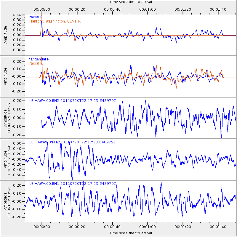
HAWA Hanford, Washington, USA - Earthquake Result Viewer
*The percent match for this event was below the threshold and hence no stack was calculated.
| Earthquake location: |
Solomon Islands |
| Earthquake latitude/longitude: |
-10.3/162.0 |
| Earthquake time(UTC): |
2011/07/20 (201) 22:04:59 GMT |
| Earthquake Depth: |
21 km |
| Earthquake Magnitude: |
5.9 MB, 5.6 MS, 6.0 MW, 6.0 MW |
| Earthquake Catalog/Contributor: |
WHDF/NEIC |
|
| Network: |
US United States National Seismic Network |
| Station: |
HAWA Hanford, Washington, USA |
| Lat/Lon: |
46.39 N/119.53 W |
| Elevation: |
364 m |
|
| Distance: |
89.6 deg |
| Az: |
42.7 deg |
| Baz: |
254.601 deg |
| Ray Param: |
$rayparam |
*The percent match for this event was below the threshold and hence was not used in the summary stack. |
|
| Radial Match: |
72.13574 % |
| Radial Bump: |
400 |
| Transverse Match: |
68.70415 % |
| Transverse Bump: |
400 |
| SOD ConfigId: |
558545 |
| Insert Time: |
2013-09-18 22:59:42.200 +0000 |
| GWidth: |
2.5 |
| Max Bumps: |
400 |
| Tol: |
0.001 |
|
Signal To Noise
| Channel | StoN | STA | LTA |
| US:HAWA:00:BHZ:20110720T22:17:23.648979Z | 3.4209008 | 3.606897E-7 | 1.0543705E-7 |
| US:HAWA:00:BH1:20110720T22:17:23.648979Z | 0.64315104 | 4.5796348E-8 | 7.120621E-8 |
| US:HAWA:00:BH2:20110720T22:17:23.648979Z | 1.018725 | 6.3633934E-8 | 6.246429E-8 |
| Arrivals |
| Ps | |
| PpPs | |
| PsPs/PpSs | |


