You are here: Home > Network List > IU - Global Seismograph Network (GSN - IRIS/USGS) Stations List
> Station MAJO Matsushiro, Japan > Earthquake Result Viewer
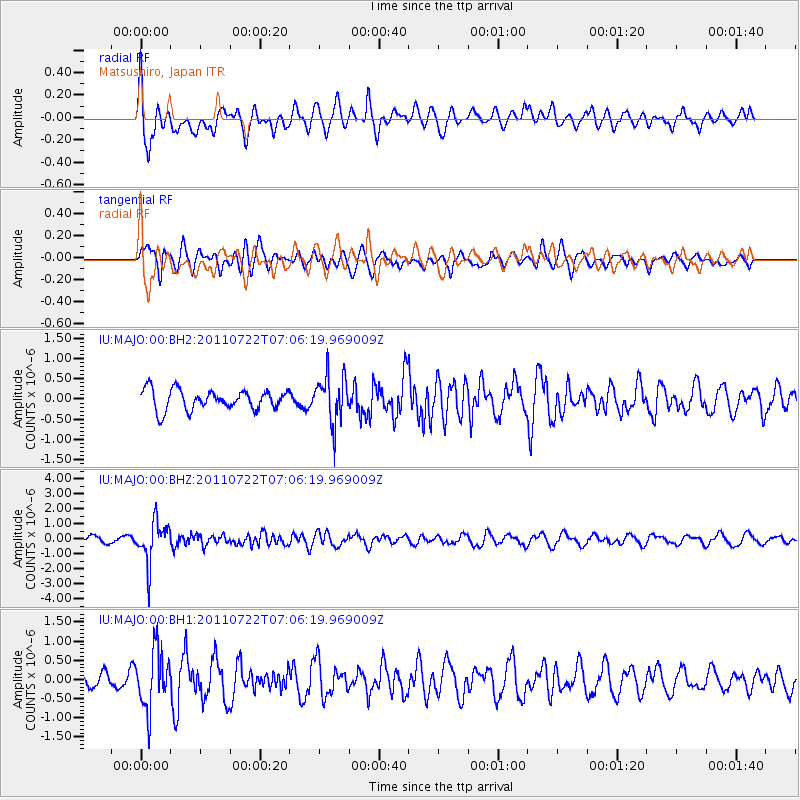
MAJO Matsushiro, Japan - Earthquake Result Viewer
*The percent match for this event was below the threshold and hence no stack was calculated.
| Earthquake location: |
Fiji Islands Region |
| Earthquake latitude/longitude: |
-20.3/-178.6 |
| Earthquake time(UTC): |
2011/07/22 (203) 06:56:40 GMT |
| Earthquake Depth: |
612 km |
| Earthquake Magnitude: |
5.9 MB, 6.0 MW, 5.9 MW |
| Earthquake Catalog/Contributor: |
WHDF/NEIC |
|
| Network: |
IU Global Seismograph Network (GSN - IRIS/USGS) |
| Station: |
MAJO Matsushiro, Japan |
| Lat/Lon: |
36.55 N/138.20 E |
| Elevation: |
405 m |
|
| Distance: |
69.7 deg |
| Az: |
324.013 deg |
| Baz: |
136.78 deg |
| Ray Param: |
$rayparam |
*The percent match for this event was below the threshold and hence was not used in the summary stack. |
|
| Radial Match: |
64.013695 % |
| Radial Bump: |
400 |
| Transverse Match: |
55.960674 % |
| Transverse Bump: |
400 |
| SOD ConfigId: |
558545 |
| Insert Time: |
2013-09-18 23:02:26.833 +0000 |
| GWidth: |
2.5 |
| Max Bumps: |
400 |
| Tol: |
0.001 |
|
Signal To Noise
| Channel | StoN | STA | LTA |
| IU:MAJO:00:BHZ:20110722T07:06:19.969009Z | 4.627279 | 1.365462E-6 | 2.9508962E-7 |
| IU:MAJO:00:BH1:20110722T07:06:19.969009Z | 4.2850466 | 7.529948E-7 | 1.7572616E-7 |
| IU:MAJO:00:BH2:20110722T07:06:19.969009Z | 2.3780656 | 5.868074E-7 | 2.467583E-7 |
| Arrivals |
| Ps | |
| PpPs | |
| PsPs/PpSs | |


