You are here: Home > Network List > US - United States National Seismic Network Stations List
> Station BOZ Bozeman, Montana, USA > Earthquake Result Viewer
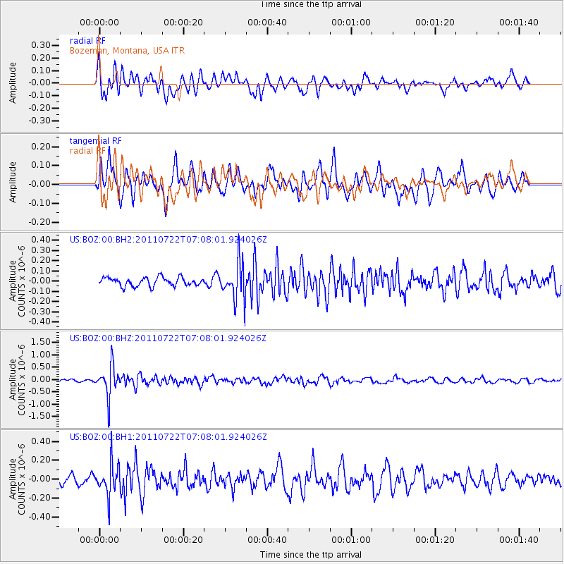
BOZ Bozeman, Montana, USA - Earthquake Result Viewer
*The percent match for this event was below the threshold and hence no stack was calculated.
| Earthquake location: |
Fiji Islands Region |
| Earthquake latitude/longitude: |
-20.3/-178.6 |
| Earthquake time(UTC): |
2011/07/22 (203) 06:56:40 GMT |
| Earthquake Depth: |
612 km |
| Earthquake Magnitude: |
5.9 MB, 6.0 MW, 5.9 MW |
| Earthquake Catalog/Contributor: |
WHDF/NEIC |
|
| Network: |
US United States National Seismic Network |
| Station: |
BOZ Bozeman, Montana, USA |
| Lat/Lon: |
45.65 N/111.63 W |
| Elevation: |
1589 m |
|
| Distance: |
89.3 deg |
| Az: |
40.21 deg |
| Baz: |
239.737 deg |
| Ray Param: |
$rayparam |
*The percent match for this event was below the threshold and hence was not used in the summary stack. |
|
| Radial Match: |
69.599655 % |
| Radial Bump: |
400 |
| Transverse Match: |
63.030148 % |
| Transverse Bump: |
352 |
| SOD ConfigId: |
558545 |
| Insert Time: |
2013-09-18 23:03:03.307 +0000 |
| GWidth: |
2.5 |
| Max Bumps: |
400 |
| Tol: |
0.001 |
|
Signal To Noise
| Channel | StoN | STA | LTA |
| US:BOZ:00:BHZ:20110722T07:08:01.924026Z | 12.748195 | 6.5572584E-7 | 5.143676E-8 |
| US:BOZ:00:BH1:20110722T07:08:01.924026Z | 2.914434 | 1.7653903E-7 | 6.057403E-8 |
| US:BOZ:00:BH2:20110722T07:08:01.924026Z | 4.4383764 | 1.8584903E-7 | 4.18732E-8 |
| Arrivals |
| Ps | |
| PpPs | |
| PsPs/PpSs | |


