You are here: Home > Network List > US - United States National Seismic Network Stations List
> Station HAWA Hanford, Washington, USA > Earthquake Result Viewer
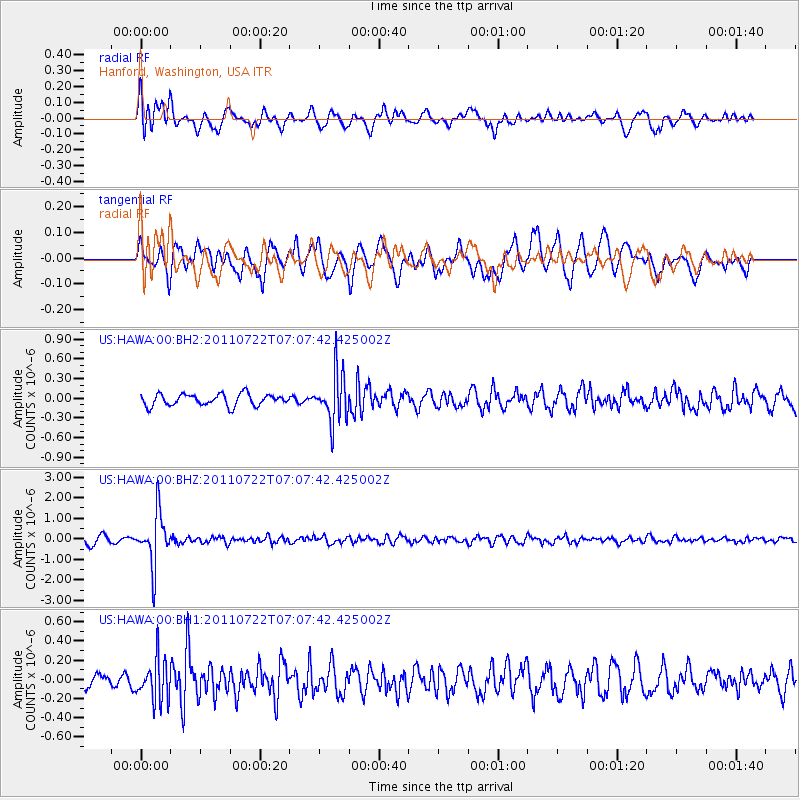
HAWA Hanford, Washington, USA - Earthquake Result Viewer
*The percent match for this event was below the threshold and hence no stack was calculated.
| Earthquake location: |
Fiji Islands Region |
| Earthquake latitude/longitude: |
-20.3/-178.6 |
| Earthquake time(UTC): |
2011/07/22 (203) 06:56:40 GMT |
| Earthquake Depth: |
612 km |
| Earthquake Magnitude: |
5.9 MB, 6.0 MW, 5.9 MW |
| Earthquake Catalog/Contributor: |
WHDF/NEIC |
|
| Network: |
US United States National Seismic Network |
| Station: |
HAWA Hanford, Washington, USA |
| Lat/Lon: |
46.39 N/119.53 W |
| Elevation: |
364 m |
|
| Distance: |
85.1 deg |
| Az: |
36.57 deg |
| Baz: |
233.889 deg |
| Ray Param: |
$rayparam |
*The percent match for this event was below the threshold and hence was not used in the summary stack. |
|
| Radial Match: |
68.9119 % |
| Radial Bump: |
400 |
| Transverse Match: |
71.73334 % |
| Transverse Bump: |
400 |
| SOD ConfigId: |
558545 |
| Insert Time: |
2013-09-18 23:03:17.538 +0000 |
| GWidth: |
2.5 |
| Max Bumps: |
400 |
| Tol: |
0.001 |
|
Signal To Noise
| Channel | StoN | STA | LTA |
| US:HAWA:00:BHZ:20110722T07:07:42.425002Z | 9.087497 | 1.2762985E-6 | 1.4044555E-7 |
| US:HAWA:00:BH1:20110722T07:07:42.425002Z | 3.0129337 | 2.1620805E-7 | 7.175998E-8 |
| US:HAWA:00:BH2:20110722T07:07:42.425002Z | 4.261401 | 3.7834738E-7 | 8.878474E-8 |
| Arrivals |
| Ps | |
| PpPs | |
| PsPs/PpSs | |


