You are here: Home > Network List > TA - USArray Transportable Network (new EarthScope stations) Stations List
> Station U57A Blanch, NC, USA > Earthquake Result Viewer
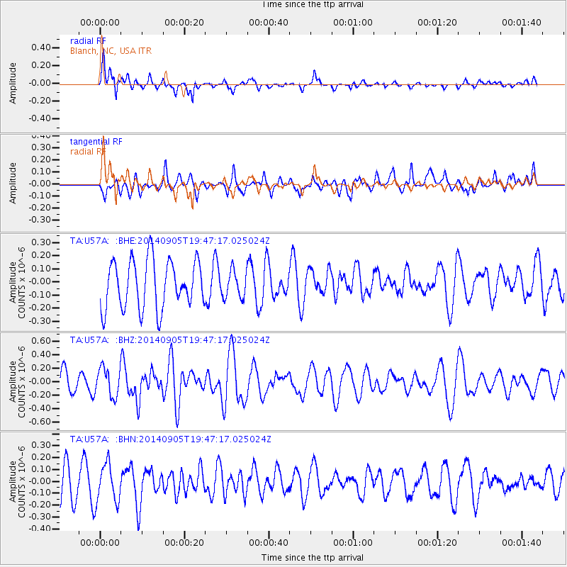
U57A Blanch, NC, USA - Earthquake Result Viewer
*The percent match for this event was below the threshold and hence no stack was calculated.
| Earthquake location: |
Easter Island Region |
| Earthquake latitude/longitude: |
-26.7/-114.3 |
| Earthquake time(UTC): |
2014/09/05 (248) 19:36:32 GMT |
| Earthquake Depth: |
21 km |
| Earthquake Magnitude: |
5.8 MWW, 5.7 MWB, 5.8 MWC |
| Earthquake Catalog/Contributor: |
NEIC PDE/NEIC COMCAT |
|
| Network: |
TA USArray Transportable Network (new EarthScope stations) |
| Station: |
U57A Blanch, NC, USA |
| Lat/Lon: |
36.43 N/79.34 W |
| Elevation: |
178 m |
|
| Distance: |
70.9 deg |
| Az: |
29.269 deg |
| Baz: |
212.835 deg |
| Ray Param: |
$rayparam |
*The percent match for this event was below the threshold and hence was not used in the summary stack. |
|
| Radial Match: |
74.93322 % |
| Radial Bump: |
400 |
| Transverse Match: |
46.767075 % |
| Transverse Bump: |
400 |
| SOD ConfigId: |
3390531 |
| Insert Time: |
2019-04-13 21:10:48.384 +0000 |
| GWidth: |
2.5 |
| Max Bumps: |
400 |
| Tol: |
0.001 |
|
Signal To Noise
| Channel | StoN | STA | LTA |
| TA:U57A: :BHZ:20140905T19:47:17.025024Z | 1.6255951 | 2.1694738E-7 | 1.334572E-7 |
| TA:U57A: :BHN:20140905T19:47:17.025024Z | 1.0748668 | 1.546103E-7 | 1.4384136E-7 |
| TA:U57A: :BHE:20140905T19:47:17.025024Z | 0.55244553 | 1.0225349E-7 | 1.8509245E-7 |
| Arrivals |
| Ps | |
| PpPs | |
| PsPs/PpSs | |


