You are here: Home > Network List > US - United States National Seismic Network Stations List
> Station MSO Missoula, Montana, USA > Earthquake Result Viewer
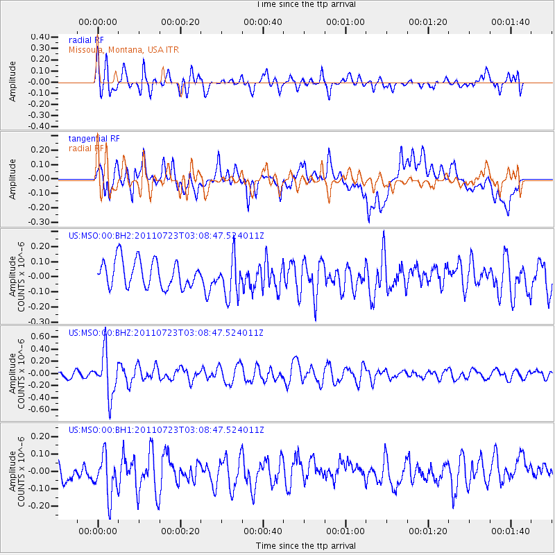
MSO Missoula, Montana, USA - Earthquake Result Viewer
*The percent match for this event was below the threshold and hence no stack was calculated.
| Earthquake location: |
Chile-Argentina Border Region |
| Earthquake latitude/longitude: |
-29.3/-69.7 |
| Earthquake time(UTC): |
2011/07/23 (204) 02:56:51 GMT |
| Earthquake Depth: |
103 km |
| Earthquake Magnitude: |
5.5 MW, 5.5 MB, 5.5 MW |
| Earthquake Catalog/Contributor: |
NEIC PDE/NEIC PDE-M |
|
| Network: |
US United States National Seismic Network |
| Station: |
MSO Missoula, Montana, USA |
| Lat/Lon: |
46.83 N/113.94 W |
| Elevation: |
1264 m |
|
| Distance: |
85.7 deg |
| Az: |
331.292 deg |
| Baz: |
142.348 deg |
| Ray Param: |
$rayparam |
*The percent match for this event was below the threshold and hence was not used in the summary stack. |
|
| Radial Match: |
56.59288 % |
| Radial Bump: |
400 |
| Transverse Match: |
47.654846 % |
| Transverse Bump: |
400 |
| SOD ConfigId: |
558545 |
| Insert Time: |
2013-09-18 23:06:45.540 +0000 |
| GWidth: |
2.5 |
| Max Bumps: |
400 |
| Tol: |
0.001 |
|
Signal To Noise
| Channel | StoN | STA | LTA |
| US:MSO:00:BHZ:20110723T03:08:47.524011Z | 4.499192 | 3.629869E-7 | 8.067824E-8 |
| US:MSO:00:BH1:20110723T03:08:47.524011Z | 1.7101873 | 1.228498E-7 | 7.1834116E-8 |
| US:MSO:00:BH2:20110723T03:08:47.524011Z | 1.4973065 | 1.3186123E-7 | 8.806562E-8 |
| Arrivals |
| Ps | |
| PpPs | |
| PsPs/PpSs | |


