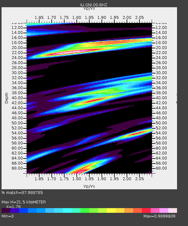
GNI Garni, Armenia - Earthquake Result Viewer

Earthquake location: Near East Coast Of Honshu, Japan
Earthquake latitude/longitude: 38.9/141.8
Earthquake time(UTC): 2011/07/23 (204) 04:34:24 GMT
Earthquake Depth: 41 km
Earthquake Magnitude: 5.9 MB, 5.9 MS, 6.4 MW, 6.3 MW
Earthquake Catalog/Contributor: WHDF/NEIC
Network: IU Global Seismograph Network (GSN - IRIS/USGS)
Station: GNI Garni, Armenia
Lat/Lon: 40.15 N/44.74 E
Elevation: 1609 m
Distance: 70.9 deg
Az: 306.369 deg
Baz: 55.057 deg
Ray Param: 0.054635197
Estimated Moho Depth: 21.5 km
Estimated Crust Vp/Vs: 1.78
Assumed Crust Vp: 6.291 km/s
Estimated Crust Vs: 3.534 km/s
Estimated Crust Poisson's Ratio: 0.27
Radial Match: 87.988785 %
Radial Bump: 400
Transverse Match: 83.997665 %
Transverse Bump: 400
SOD ConfigId: 558545
Insert Time: 2013-09-18 23:08:35.223 +0000
GWidth: 2.5
Max Bumps: 400
Tol: 0.001

Signal To Noise

ChannelStoNSTALTA
IU:GNI:00:BHZ:20110723T04:45:05.869026Z33.8132172.4747073E-67.318758E-8
IU:GNI:00:BH1:20110723T04:45:05.869026Z7.07876876.33194E-78.944974E-8
IU:GNI:00:BH2:20110723T04:45:05.869026Z12.3048278.7377424E-77.101069E-8
Arrivals
Ps2.8 SECOND
PpPs9.2 SECOND
PsPs/PpSs12 SECOND