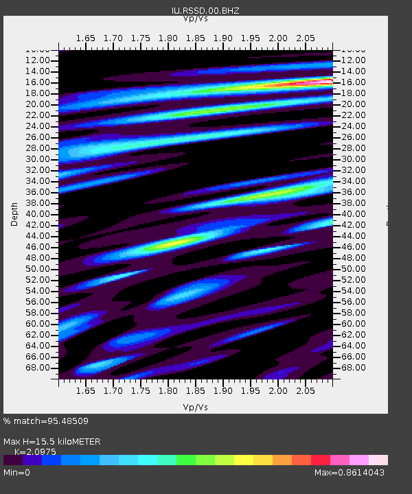
RSSD Black Hills, South Dakota, USA - Earthquake Result Viewer
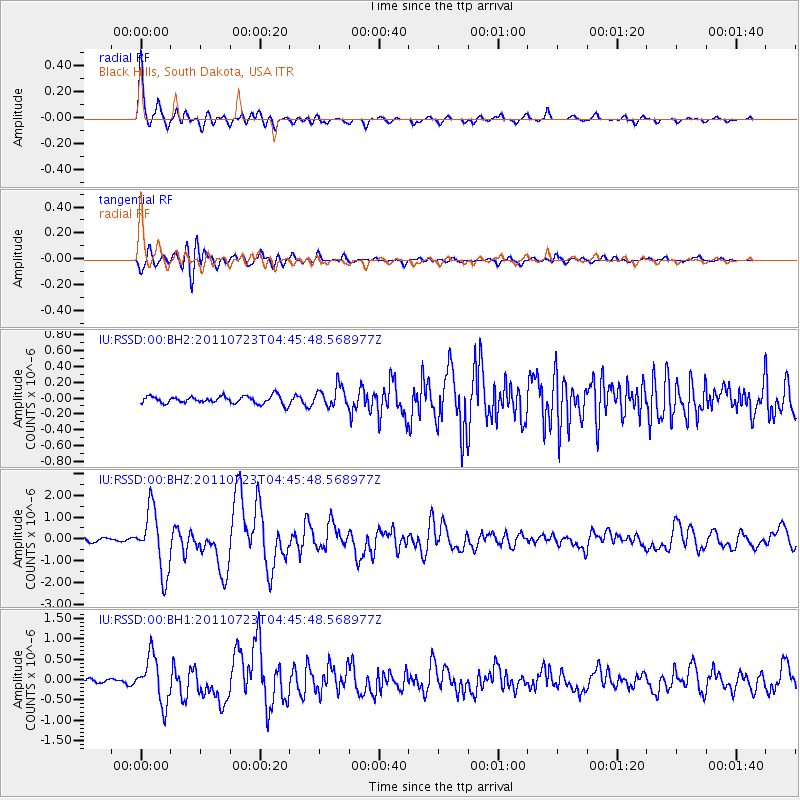
Earthquake location: Near East Coast Of Honshu, Japan
Earthquake latitude/longitude: 38.9/141.8
Earthquake time(UTC): 2011/07/23 (204) 04:34:24 GMT
Earthquake Depth: 41 km
Earthquake Magnitude: 5.9 MB, 5.9 MS, 6.4 MW, 6.3 MW
Earthquake Catalog/Contributor: WHDF/NEIC
Network: IU Global Seismograph Network (GSN - IRIS/USGS)
Station: RSSD Black Hills, South Dakota, USA
Lat/Lon: 44.12 N/104.04 W
Elevation: 2090 m
Distance: 78.2 deg
Az: 42.166 deg
Baz: 313.338 deg
Ray Param: 0.049715422
Estimated Moho Depth: 15.5 km
Estimated Crust Vp/Vs: 2.10
Assumed Crust Vp: 6.242 km/s
Estimated Crust Vs: 2.976 km/s
Estimated Crust Poisson's Ratio: 0.35
Radial Match: 95.48509 %
Radial Bump: 380
Transverse Match: 88.99426 %
Transverse Bump: 400
SOD ConfigId: 558545
Insert Time: 2013-09-18 23:09:18.343 +0000
GWidth: 2.5
Max Bumps: 400
Tol: 0.001

Signal To Noise

ChannelStoNSTALTA
IU:RSSD:00:BHZ:20110723T04:45:48.568977Z19.7270131.4259191E-67.228257E-8
IU:RSSD:00:BH1:20110723T04:45:48.568977Z8.6528965.663693E-76.545431E-8
IU:RSSD:00:BH2:20110723T04:45:48.568977Z2.7567811.3041948E-74.730861E-8
Arrivals
Ps2.8 SECOND
PpPs7.5 SECOND
PsPs/PpSs10 SECOND