You are here: Home > Network List > II - Global Seismograph Network (GSN - IRIS/IDA) Stations List
> Station CMLA Cha de Macela, Sao Miguel Island, Azores > Earthquake Result Viewer
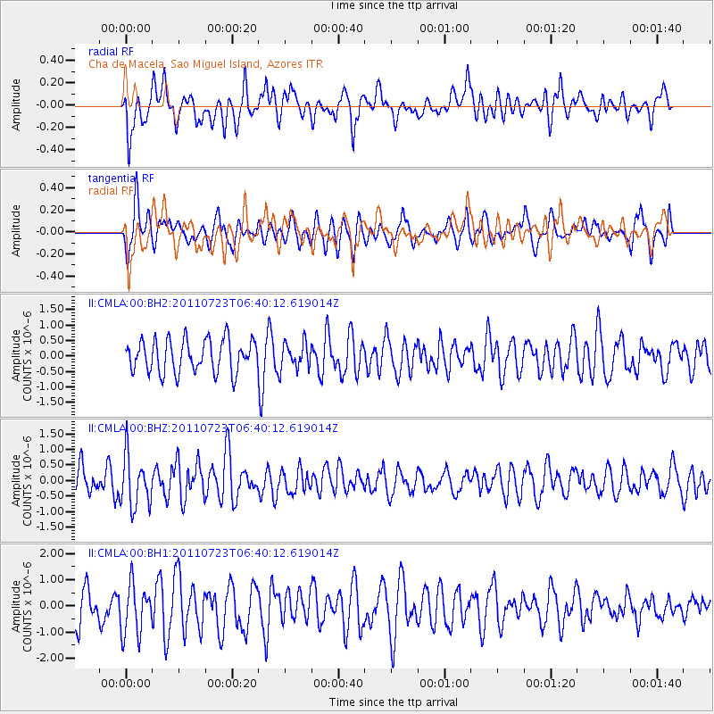
CMLA Cha de Macela, Sao Miguel Island, Azores - Earthquake Result Viewer
*The percent match for this event was below the threshold and hence no stack was calculated.
| Earthquake location: |
Alaska Peninsula |
| Earthquake latitude/longitude: |
54.7/-161.1 |
| Earthquake time(UTC): |
2011/07/23 (204) 06:28:34 GMT |
| Earthquake Depth: |
23 km |
| Earthquake Magnitude: |
5.7 MW, 5.5 MB, 5.7 ML |
| Earthquake Catalog/Contributor: |
NEIC PDE/NEIC PDE-M |
|
| Network: |
II Global Seismograph Network (GSN - IRIS/IDA) |
| Station: |
CMLA Cha de Macela, Sao Miguel Island, Azores |
| Lat/Lon: |
37.76 N/25.52 W |
| Elevation: |
429 m |
|
| Distance: |
80.3 deg |
| Az: |
34.21 deg |
| Baz: |
335.68 deg |
| Ray Param: |
$rayparam |
*The percent match for this event was below the threshold and hence was not used in the summary stack. |
|
| Radial Match: |
55.28671 % |
| Radial Bump: |
400 |
| Transverse Match: |
52.365353 % |
| Transverse Bump: |
400 |
| SOD ConfigId: |
558545 |
| Insert Time: |
2013-09-18 23:12:55.316 +0000 |
| GWidth: |
2.5 |
| Max Bumps: |
400 |
| Tol: |
0.001 |
|
Signal To Noise
| Channel | StoN | STA | LTA |
| II:CMLA:00:BHZ:20110723T06:40:12.619014Z | 2.1899004 | 8.261727E-7 | 3.7726497E-7 |
| II:CMLA:00:BH1:20110723T06:40:12.619014Z | 1.4768412 | 9.705764E-7 | 6.571975E-7 |
| II:CMLA:00:BH2:20110723T06:40:12.619014Z | 0.78493375 | 4.120157E-7 | 5.249051E-7 |
| Arrivals |
| Ps | |
| PpPs | |
| PsPs/PpSs | |


