You are here: Home > Network List > US - United States National Seismic Network Stations List
> Station DGMT Dagmar, Montana, USA > Earthquake Result Viewer
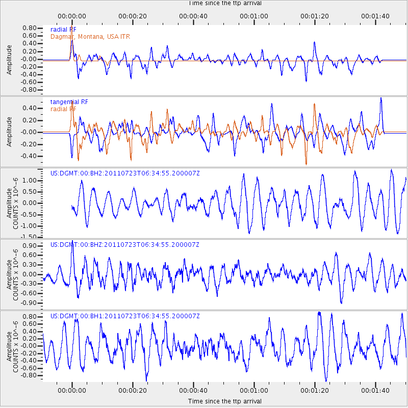
DGMT Dagmar, Montana, USA - Earthquake Result Viewer
*The percent match for this event was below the threshold and hence no stack was calculated.
| Earthquake location: |
Alaska Peninsula |
| Earthquake latitude/longitude: |
54.7/-161.1 |
| Earthquake time(UTC): |
2011/07/23 (204) 06:28:34 GMT |
| Earthquake Depth: |
23 km |
| Earthquake Magnitude: |
5.7 MW, 5.5 MB, 5.7 ML |
| Earthquake Catalog/Contributor: |
NEIC PDE/NEIC PDE-M |
|
| Network: |
US United States National Seismic Network |
| Station: |
DGMT Dagmar, Montana, USA |
| Lat/Lon: |
48.47 N/104.20 W |
| Elevation: |
0.0 m |
|
| Distance: |
35.1 deg |
| Az: |
76.126 deg |
| Baz: |
302.13 deg |
| Ray Param: |
$rayparam |
*The percent match for this event was below the threshold and hence was not used in the summary stack. |
|
| Radial Match: |
60.163826 % |
| Radial Bump: |
400 |
| Transverse Match: |
45.259182 % |
| Transverse Bump: |
400 |
| SOD ConfigId: |
558545 |
| Insert Time: |
2013-09-18 23:14:45.350 +0000 |
| GWidth: |
2.5 |
| Max Bumps: |
400 |
| Tol: |
0.001 |
|
Signal To Noise
| Channel | StoN | STA | LTA |
| US:DGMT:00:BHZ:20110723T06:34:55.200007Z | 2.3322933 | 4.8799103E-7 | 2.0923228E-7 |
| US:DGMT:00:BH1:20110723T06:34:55.200007Z | 1.2288762 | 5.023828E-7 | 4.0881483E-7 |
| US:DGMT:00:BH2:20110723T06:34:55.200007Z | 0.9445209 | 4.0599554E-7 | 4.2984283E-7 |
| Arrivals |
| Ps | |
| PpPs | |
| PsPs/PpSs | |


