You are here: Home > Network List > US - United States National Seismic Network Stations List
> Station AMTX Amarillo, Texas, USA > Earthquake Result Viewer
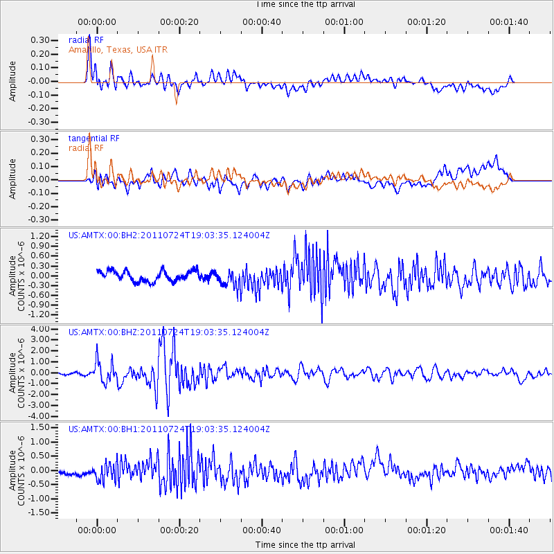
AMTX Amarillo, Texas, USA - Earthquake Result Viewer
*The percent match for this event was below the threshold and hence no stack was calculated.
| Earthquake location: |
Near East Coast Of Honshu, Japan |
| Earthquake latitude/longitude: |
37.7/141.4 |
| Earthquake time(UTC): |
2011/07/24 (205) 18:51:24 GMT |
| Earthquake Depth: |
35 km |
| Earthquake Magnitude: |
6.3 MB, 5.9 MS, 6.3 MW, 6.3 MW |
| Earthquake Catalog/Contributor: |
WHDF/NEIC |
|
| Network: |
US United States National Seismic Network |
| Station: |
AMTX Amarillo, Texas, USA |
| Lat/Lon: |
34.53 N/101.41 W |
| Elevation: |
1010 m |
|
| Distance: |
87.4 deg |
| Az: |
47.311 deg |
| Baz: |
315.093 deg |
| Ray Param: |
$rayparam |
*The percent match for this event was below the threshold and hence was not used in the summary stack. |
|
| Radial Match: |
78.714294 % |
| Radial Bump: |
400 |
| Transverse Match: |
55.748604 % |
| Transverse Bump: |
400 |
| SOD ConfigId: |
558545 |
| Insert Time: |
2013-09-18 23:19:30.056 +0000 |
| GWidth: |
2.5 |
| Max Bumps: |
400 |
| Tol: |
0.001 |
|
Signal To Noise
| Channel | StoN | STA | LTA |
| US:AMTX:00:BHZ:20110724T19:03:35.124004Z | 10.70393 | 9.920738E-7 | 9.268313E-8 |
| US:AMTX:00:BH1:20110724T19:03:35.124004Z | 3.0047493 | 2.8652573E-7 | 9.535762E-8 |
| US:AMTX:00:BH2:20110724T19:03:35.124004Z | 1.9348527 | 3.0220522E-7 | 1.561903E-7 |
| Arrivals |
| Ps | |
| PpPs | |
| PsPs/PpSs | |


