You are here: Home > Network List > CN - Canadian National Seismograph Network Stations List
> Station INK INUVIK, NT, CANADA.ANADA > Earthquake Result Viewer
INK INUVIK, NT, CANADA.ANADA - Earthquake Result Viewer
| Earthquake location: |
Southern Xinjiang, China |
| Earthquake latitude/longitude: |
35.5/81.5 |
| Earthquake time(UTC): |
2008/03/20 (080) 22:32:57 GMT |
| Earthquake Depth: |
10 km |
| Earthquake Magnitude: |
6.3 MB, 7.3 MS, 7.2 MW, 7.1 MW |
| Earthquake Catalog/Contributor: |
WHDF/NEIC |
|
| Network: |
CN Canadian National Seismograph Network |
| Station: |
INK INUVIK, NT, CANADA.ANADA |
| Lat/Lon: |
68.31 N/133.52 W |
| Elevation: |
40 m |
|
| Distance: |
73.3 deg |
| Az: |
12.862 deg |
| Baz: |
330.75 deg |
| Ray Param: |
0.053119317 |
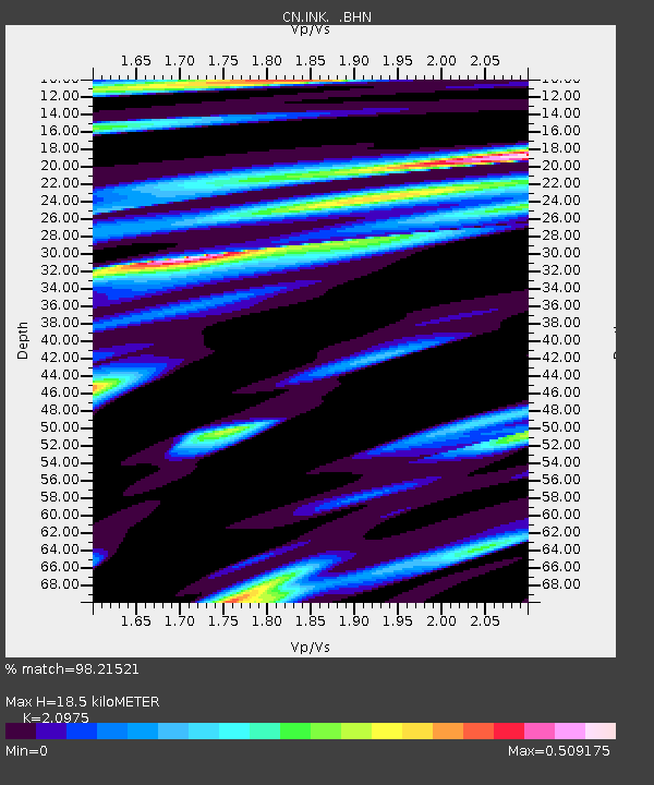
| Estimated Moho Depth: |
18.5 km |
| Estimated Crust Vp/Vs: |
2.10 |
| Assumed Crust Vp: |
6.171 km/s |
| Estimated Crust Vs: |
2.942 km/s |
| Estimated Crust Poisson's Ratio: |
0.35 |
|
| Radial Match: |
98.21521 % |
| Radial Bump: |
309 |
| Transverse Match: |
93.07579 % |
| Transverse Bump: |
400 |
| SOD ConfigId: |
2504 |
| Insert Time: |
2010-02-27 06:13:29.888 +0000 |
| GWidth: |
2.5 |
| Max Bumps: |
400 |
| Tol: |
0.001 |
|
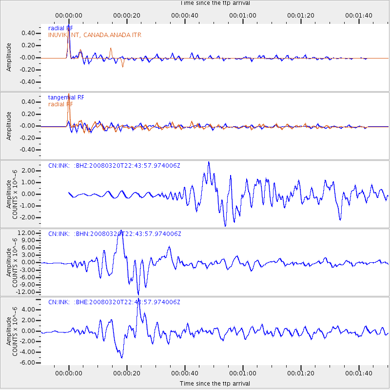
Signal To Noise
| Channel | StoN | STA | LTA |
| CN:INK: :BHN:20080320T22:43:57.974006Z | 5.0246367 | 6.682778E-7 | 1.3300023E-7 |
| CN:INK: :BHE:20080320T22:43:57.974006Z | 2.0794396 | 3.2261465E-7 | 1.55145E-7 |
| CN:INK: :BHZ:20080320T22:43:57.974006Z | 0.9836923 | 1.4858719E-7 | 1.5105049E-7 |
| Arrivals |
| Ps | 3.4 SECOND |
| PpPs | 9.0 SECOND |
| PsPs/PpSs | 12 SECOND |


