MAKZ Makanchi, Kazakhstan - Earthquake Result Viewer
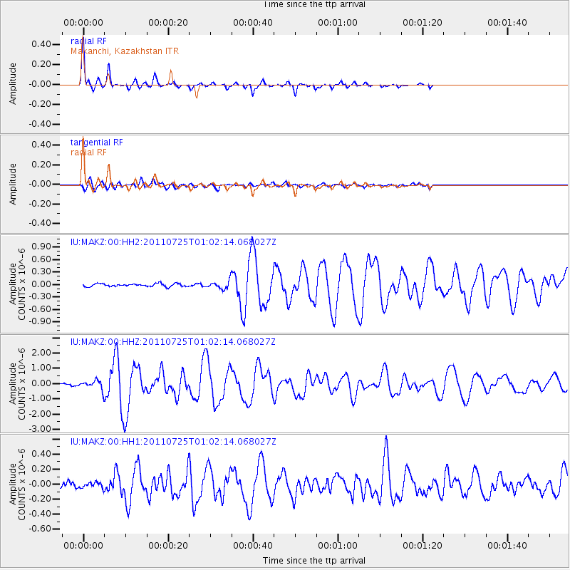
Earthquake location: New Ireland Region, P.N.G.
Earthquake latitude/longitude: -3.2/150.6
Earthquake time(UTC): 2011/07/25 (206) 00:50:47 GMT
Earthquake Depth: 10 km
Earthquake Magnitude: 5.9 MB, 6.3 MS, 6.4 MW, 6.3 MW
Earthquake Catalog/Contributor: WHDF/NEIC
Network: IU Global Seismograph Network (GSN - IRIS/USGS)
Station: MAKZ Makanchi, Kazakhstan
Lat/Lon: 46.81 N/81.98 E
Elevation: 600 m
Distance: 77.9 deg
Az: 319.138 deg
Baz: 108.007 deg
Ray Param: 0.050015077
Estimated Moho Depth: 37.75 km
Estimated Crust Vp/Vs: 2.02
Assumed Crust Vp: 6.571 km/s
Estimated Crust Vs: 3.249 km/s
Estimated Crust Poisson's Ratio: 0.34
Radial Match: 96.851654 %
Radial Bump: 200
Transverse Match: 73.09977 %
Transverse Bump: 400
SOD ConfigId: 558545
Insert Time: 2013-09-18 23:22:44.027 +0000
GWidth: 2.5
Max Bumps: 400
Tol: 0.001

Signal To Noise

ChannelStoNSTALTA
IU:MAKZ:00:HHZ:20110725T01:02:14.068027Z5.6364252.798446E-74.9649312E-8
IU:MAKZ:00:HH1:20110725T01:02:14.068027Z1.16112383.5887517E-83.090757E-8
IU:MAKZ:00:HH2:20110725T01:02:14.068027Z2.76222169.533629E-83.4514354E-8
Arrivals
Ps6.0 SECOND
PpPs17 SECOND
PsPs/PpSs23 SECOND