You are here: Home > Network List > US - United States National Seismic Network Stations List
> Station MSO Missoula, Montana, USA > Earthquake Result Viewer
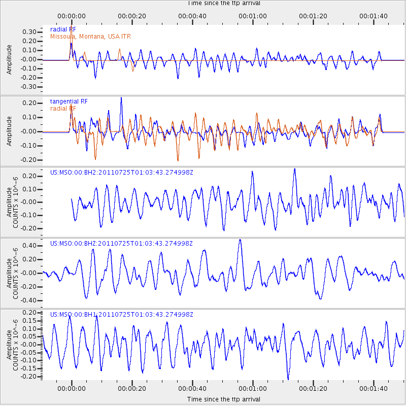
MSO Missoula, Montana, USA - Earthquake Result Viewer
*The percent match for this event was below the threshold and hence no stack was calculated.
| Earthquake location: |
New Ireland Region, P.N.G. |
| Earthquake latitude/longitude: |
-3.2/150.6 |
| Earthquake time(UTC): |
2011/07/25 (206) 00:50:47 GMT |
| Earthquake Depth: |
10 km |
| Earthquake Magnitude: |
5.9 MB, 6.3 MS, 6.4 MW, 6.3 MW |
| Earthquake Catalog/Contributor: |
WHDF/NEIC |
|
| Network: |
US United States National Seismic Network |
| Station: |
MSO Missoula, Montana, USA |
| Lat/Lon: |
46.83 N/113.94 W |
| Elevation: |
1264 m |
|
| Distance: |
96.0 deg |
| Az: |
43.419 deg |
| Baz: |
271.79 deg |
| Ray Param: |
$rayparam |
*The percent match for this event was below the threshold and hence was not used in the summary stack. |
|
| Radial Match: |
60.163555 % |
| Radial Bump: |
400 |
| Transverse Match: |
58.967445 % |
| Transverse Bump: |
393 |
| SOD ConfigId: |
558545 |
| Insert Time: |
2013-09-18 23:23:21.561 +0000 |
| GWidth: |
2.5 |
| Max Bumps: |
400 |
| Tol: |
0.001 |
|
Signal To Noise
| Channel | StoN | STA | LTA |
| US:MSO:00:BHZ:20110725T01:03:43.274998Z | 2.4159958 | 1.4858381E-7 | 6.1500025E-8 |
| US:MSO:00:BH1:20110725T01:03:43.274998Z | 1.6647362 | 1.0566085E-7 | 6.3470026E-8 |
| US:MSO:00:BH2:20110725T01:03:43.274998Z | 0.81751627 | 6.257192E-8 | 7.653906E-8 |
| Arrivals |
| Ps | |
| PpPs | |
| PsPs/PpSs | |


