You are here: Home > Network List > IU - Global Seismograph Network (GSN - IRIS/USGS) Stations List
> Station PMG Port Moresby, New Guinea > Earthquake Result Viewer
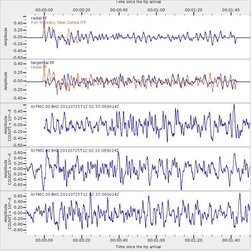
PMG Port Moresby, New Guinea - Earthquake Result Viewer
*The percent match for this event was below the threshold and hence no stack was calculated.
| Earthquake location: |
Near East Coast Of Honshu, Japan |
| Earthquake latitude/longitude: |
35.3/140.9 |
| Earthquake time(UTC): |
2011/07/25 (206) 11:54:54 GMT |
| Earthquake Depth: |
46 km |
| Earthquake Magnitude: |
5.6 MW |
| Earthquake Catalog/Contributor: |
NEIC PDE/NEIC PDE-M |
|
| Network: |
IU Global Seismograph Network (GSN - IRIS/USGS) |
| Station: |
PMG Port Moresby, New Guinea |
| Lat/Lon: |
9.40 S/147.16 E |
| Elevation: |
90 m |
|
| Distance: |
44.8 deg |
| Az: |
171.267 deg |
| Baz: |
352.767 deg |
| Ray Param: |
$rayparam |
*The percent match for this event was below the threshold and hence was not used in the summary stack. |
|
| Radial Match: |
55.776554 % |
| Radial Bump: |
400 |
| Transverse Match: |
48.502663 % |
| Transverse Bump: |
400 |
| SOD ConfigId: |
558545 |
| Insert Time: |
2013-09-18 23:26:52.659 +0000 |
| GWidth: |
2.5 |
| Max Bumps: |
400 |
| Tol: |
0.001 |
|
Signal To Noise
| Channel | StoN | STA | LTA |
| IU:PMG:00:BHZ:20110725T12:02:33.069014Z | 2.481969 | 4.1947195E-7 | 1.6900772E-7 |
| IU:PMG:00:BH1:20110725T12:02:33.069014Z | 1.3828183 | 1.9981442E-7 | 1.4449795E-7 |
| IU:PMG:00:BH2:20110725T12:02:33.069014Z | 1.0917739 | 1.561365E-7 | 1.4301175E-7 |
| Arrivals |
| Ps | |
| PpPs | |
| PsPs/PpSs | |


