You are here: Home > Network List > US - United States National Seismic Network Stations List
> Station MIAR Mount Ida, Arkansas, USA > Earthquake Result Viewer
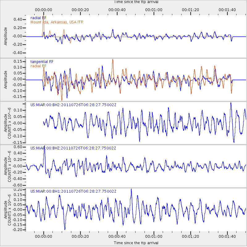
MIAR Mount Ida, Arkansas, USA - Earthquake Result Viewer
*The percent match for this event was below the threshold and hence no stack was calculated.
| Earthquake location: |
Off East Coast Of Kamchatka |
| Earthquake latitude/longitude: |
53.0/159.8 |
| Earthquake time(UTC): |
2011/07/26 (207) 06:17:37 GMT |
| Earthquake Depth: |
33 km |
| Earthquake Magnitude: |
5.6 MW, 5.1 MS, 5.4 MB, 5.4 MW |
| Earthquake Catalog/Contributor: |
WHDF/NEIC |
|
| Network: |
US United States National Seismic Network |
| Station: |
MIAR Mount Ida, Arkansas, USA |
| Lat/Lon: |
34.55 N/93.58 W |
| Elevation: |
207 m |
|
| Distance: |
72.1 deg |
| Az: |
56.203 deg |
| Baz: |
322.511 deg |
| Ray Param: |
$rayparam |
*The percent match for this event was below the threshold and hence was not used in the summary stack. |
|
| Radial Match: |
49.960545 % |
| Radial Bump: |
400 |
| Transverse Match: |
58.919544 % |
| Transverse Bump: |
400 |
| SOD ConfigId: |
558545 |
| Insert Time: |
2013-09-18 23:32:50.954 +0000 |
| GWidth: |
2.5 |
| Max Bumps: |
400 |
| Tol: |
0.001 |
|
Signal To Noise
| Channel | StoN | STA | LTA |
| US:MIAR:00:BHZ:20110726T06:28:27.75002Z | 4.0000663 | 2.4944276E-7 | 6.235966E-8 |
| US:MIAR:00:BH1:20110726T06:28:27.75002Z | 1.585332 | 5.9329746E-8 | 3.7424176E-8 |
| US:MIAR:00:BH2:20110726T06:28:27.75002Z | 1.0398735 | 4.143511E-8 | 3.9846302E-8 |
| Arrivals |
| Ps | |
| PpPs | |
| PsPs/PpSs | |


