You are here: Home > Network List > IU - Global Seismograph Network (GSN - IRIS/USGS) Stations List
> Station OTAV Otavalo, Ecuador > Earthquake Result Viewer
OTAV Otavalo, Ecuador - Earthquake Result Viewer
| Earthquake location: |
Gulf Of California |
| Earthquake latitude/longitude: |
25.1/-109.5 |
| Earthquake time(UTC): |
2011/07/26 (207) 17:44:20 GMT |
| Earthquake Depth: |
12 km |
| Earthquake Magnitude: |
5.6 MB, 5.8 MS, 6.0 MW, 6.0 MW |
| Earthquake Catalog/Contributor: |
WHDF/NEIC |
|
| Network: |
IU Global Seismograph Network (GSN - IRIS/USGS) |
| Station: |
OTAV Otavalo, Ecuador |
| Lat/Lon: |
0.24 N/78.45 W |
| Elevation: |
3510 m |
|
| Distance: |
38.9 deg |
| Az: |
124.716 deg |
| Baz: |
311.818 deg |
| Ray Param: |
0.07529174 |
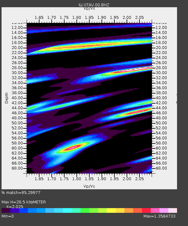
| Estimated Moho Depth: |
28.5 km |
| Estimated Crust Vp/Vs: |
2.03 |
| Assumed Crust Vp: |
6.472 km/s |
| Estimated Crust Vs: |
3.196 km/s |
| Estimated Crust Poisson's Ratio: |
0.34 |
|
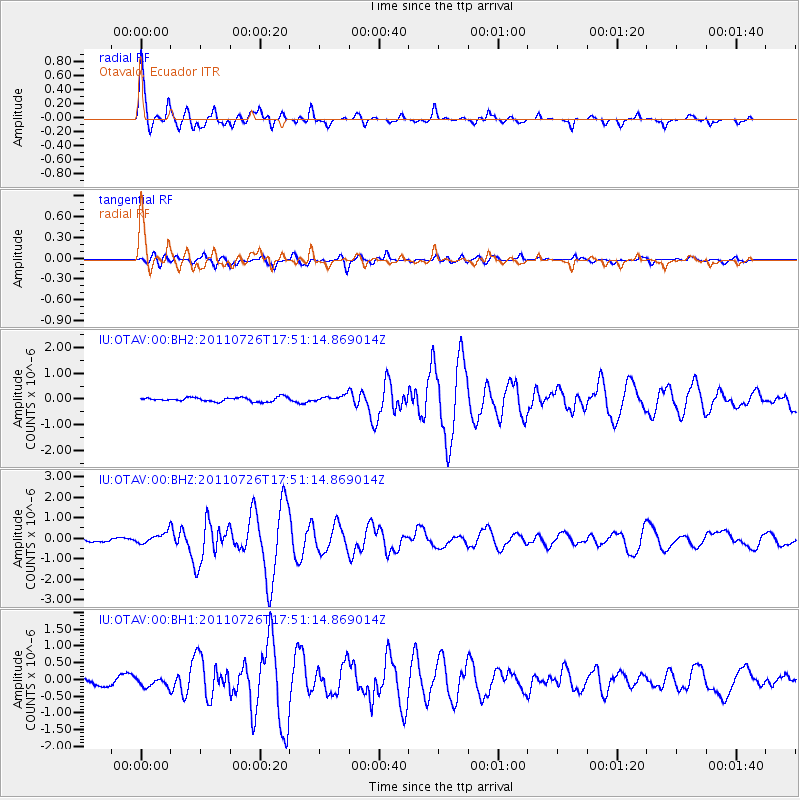
| Radial Match: |
95.29977 % |
| Radial Bump: |
400 |
| Transverse Match: |
84.70264 % |
| Transverse Bump: |
400 |
| SOD ConfigId: |
558545 |
| Insert Time: |
2013-09-18 23:35:39.031 +0000 |
| GWidth: |
2.5 |
| Max Bumps: |
400 |
| Tol: |
0.001 |
|
Signal To Noise
| Channel | StoN | STA | LTA |
| IU:OTAV:00:BHZ:20110726T17:51:14.869014Z | 3.4800081 | 2.8151425E-7 | 8.089471E-8 |
| IU:OTAV:00:BH1:20110726T17:51:14.869014Z | 0.7241168 | 1.4190694E-7 | 1.9597243E-7 |
| IU:OTAV:00:BH2:20110726T17:51:14.869014Z | 1.4871972 | 1.1852079E-7 | 7.969407E-8 |
| Arrivals |
| Ps | 4.8 SECOND |
| PpPs | 13 SECOND |
| PsPs/PpSs | 17 SECOND |


