You are here: Home > Network List > US - United States National Seismic Network Stations List
> Station LONY Lake Ozonia, New York, USA > Earthquake Result Viewer
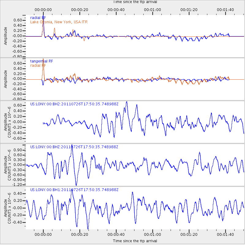
LONY Lake Ozonia, New York, USA - Earthquake Result Viewer
*The percent match for this event was below the threshold and hence no stack was calculated.
| Earthquake location: |
Gulf Of California |
| Earthquake latitude/longitude: |
25.1/-109.5 |
| Earthquake time(UTC): |
2011/07/26 (207) 17:44:20 GMT |
| Earthquake Depth: |
12 km |
| Earthquake Magnitude: |
5.6 MB, 5.8 MS, 6.0 MW, 6.0 MW |
| Earthquake Catalog/Contributor: |
WHDF/NEIC |
|
| Network: |
US United States National Seismic Network |
| Station: |
LONY Lake Ozonia, New York, USA |
| Lat/Lon: |
44.62 N/74.58 W |
| Elevation: |
440 m |
|
| Distance: |
34.3 deg |
| Az: |
46.534 deg |
| Baz: |
247.136 deg |
| Ray Param: |
$rayparam |
*The percent match for this event was below the threshold and hence was not used in the summary stack. |
|
| Radial Match: |
73.94674 % |
| Radial Bump: |
400 |
| Transverse Match: |
56.736145 % |
| Transverse Bump: |
400 |
| SOD ConfigId: |
558545 |
| Insert Time: |
2013-09-18 23:36:17.518 +0000 |
| GWidth: |
2.5 |
| Max Bumps: |
400 |
| Tol: |
0.001 |
|
Signal To Noise
| Channel | StoN | STA | LTA |
| US:LONY:00:BHZ:20110726T17:50:35.748988Z | 4.204824 | 5.1713334E-7 | 1.2298572E-7 |
| US:LONY:00:BH1:20110726T17:50:35.748988Z | 2.145844 | 2.3141394E-7 | 1.0784286E-7 |
| US:LONY:00:BH2:20110726T17:50:35.748988Z | 3.1509147 | 2.9438488E-7 | 9.342839E-8 |
| Arrivals |
| Ps | |
| PpPs | |
| PsPs/PpSs | |


