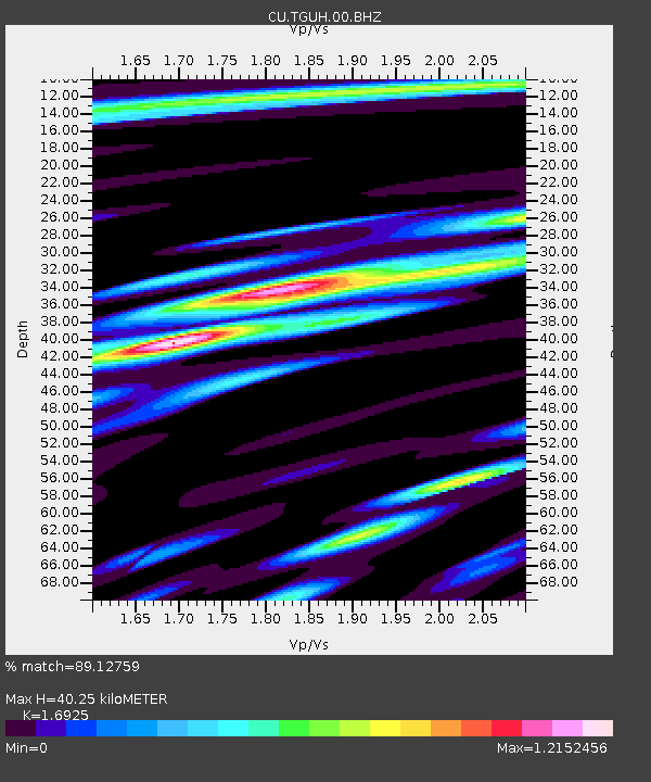
TGUH Tegucigalpa, Honduras - Earthquake Result Viewer

Earthquake location: Northern Mid-Atlantic Ridge
Earthquake latitude/longitude: 10.8/-43.4
Earthquake time(UTC): 2011/07/27 (208) 23:00:30 GMT
Earthquake Depth: 10 km
Earthquake Magnitude: 5.6 MB, 5.6 MS, 6.0 MW, 5.9 MW
Earthquake Catalog/Contributor: WHDF/NEIC
Network: CU Caribbean Network (USGS)
Station: TGUH Tegucigalpa, Honduras
Lat/Lon: 14.06 N/87.27 W
Elevation: 0.0 m
Distance: 42.9 deg
Az: 279.03 deg
Baz: 89.179 deg
Ray Param: 0.07287652
Estimated Moho Depth: 40.25 km
Estimated Crust Vp/Vs: 1.69
Assumed Crust Vp: 6.597 km/s
Estimated Crust Vs: 3.898 km/s
Estimated Crust Poisson's Ratio: 0.23
Radial Match: 89.12759 %
Radial Bump: 400
Transverse Match: 77.56792 %
Transverse Bump: 400
SOD ConfigId: 558545
Insert Time: 2013-09-18 23:36:40.101 +0000
GWidth: 2.5
Max Bumps: 400
Tol: 0.001

Signal To Noise

ChannelStoNSTALTA
CU:TGUH:00:BHZ:20110727T23:07:58.27401Z19.5702111.7257892E-68.818449E-8
CU:TGUH:00:BH1:20110727T23:07:58.27401Z1.26814632.021189E-71.5938137E-7
CU:TGUH:00:BH2:20110727T23:07:58.27401Z8.8510058.679289E-79.8059935E-8
Arrivals
Ps4.6 SECOND
PpPs15 SECOND
PsPs/PpSs20 SECOND