You are here: Home > Network List > US - United States National Seismic Network Stations List
> Station HAWA Hanford, Washington, USA > Earthquake Result Viewer
HAWA Hanford, Washington, USA - Earthquake Result Viewer
*The percent match for this event was below the threshold and hence no stack was calculated.
| Earthquake location: |
Northern Mid-Atlantic Ridge |
| Earthquake latitude/longitude: |
10.8/-43.4 |
| Earthquake time(UTC): |
2011/07/27 (208) 23:00:30 GMT |
| Earthquake Depth: |
10 km |
| Earthquake Magnitude: |
5.6 MB, 5.6 MS, 6.0 MW, 5.9 MW |
| Earthquake Catalog/Contributor: |
WHDF/NEIC |
|
| Network: |
US United States National Seismic Network |
| Station: |
HAWA Hanford, Washington, USA |
| Lat/Lon: |
46.39 N/119.53 W |
| Elevation: |
364 m |
|
| Distance: |
72.7 deg |
| Az: |
315.267 deg |
| Baz: |
92.462 deg |
| Ray Param: |
$rayparam |
*The percent match for this event was below the threshold and hence was not used in the summary stack. |
|
| Radial Match: |
70.92543 % |
| Radial Bump: |
400 |
| Transverse Match: |
62.414715 % |
| Transverse Bump: |
400 |
| SOD ConfigId: |
558545 |
| Insert Time: |
2013-09-18 23:38:50.353 +0000 |
| GWidth: |
2.5 |
| Max Bumps: |
400 |
| Tol: |
0.001 |
|
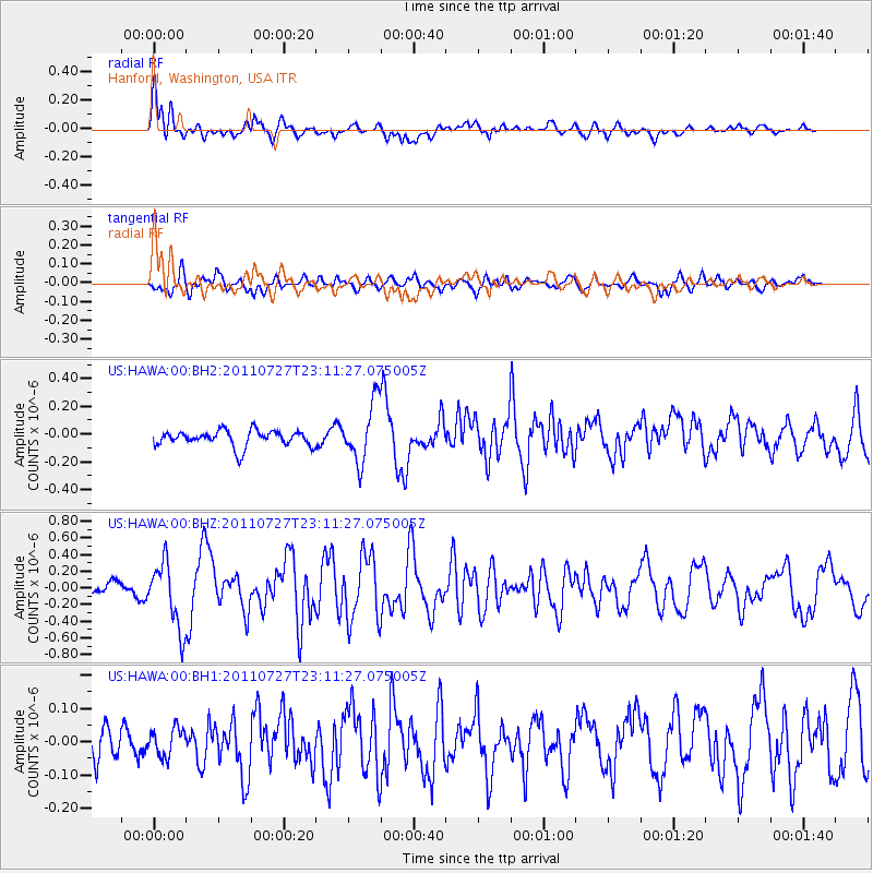
Signal To Noise
| Channel | StoN | STA | LTA |
| US:HAWA:00:BHZ:20110727T23:11:27.075005Z | 4.3677635 | 3.9669882E-7 | 9.0824244E-8 |
| US:HAWA:00:BH1:20110727T23:11:27.075005Z | 0.61181897 | 4.1347224E-8 | 6.758082E-8 |
| US:HAWA:00:BH2:20110727T23:11:27.075005Z | 3.7251117 | 2.1366618E-7 | 5.735833E-8 |
| Arrivals |
| Ps | |
| PpPs | |
| PsPs/PpSs | |


