You are here: Home > Network List > IU - Global Seismograph Network (GSN - IRIS/USGS) Stations List
> Station GNI Garni, Armenia > Earthquake Result Viewer
GNI Garni, Armenia - Earthquake Result Viewer

| Earthquake location: |
Off East Coast Of Honshu, Japan |
| Earthquake latitude/longitude: |
40.3/143.2 |
| Earthquake time(UTC): |
2011/07/28 (209) 09:01:39 GMT |
| Earthquake Depth: |
31 km |
| Earthquake Magnitude: |
5.6 MW, 5.6 MW |
| Earthquake Catalog/Contributor: |
NEIC PDE/NEIC PDE-M |
|
| Network: |
IU Global Seismograph Network (GSN - IRIS/USGS) |
| Station: |
GNI Garni, Armenia |
| Lat/Lon: |
40.15 N/44.74 E |
| Elevation: |
1609 m |
|
| Distance: |
70.9 deg |
| Az: |
306.642 deg |
| Baz: |
53.137 deg |
| Ray Param: |
0.054646965 |
| Estimated Moho Depth: |
68.75 km |
| Estimated Crust Vp/Vs: |
1.82 |
| Assumed Crust Vp: |
6.291 km/s |
| Estimated Crust Vs: |
3.452 km/s |
| Estimated Crust Poisson's Ratio: |
0.28 |
|
| Radial Match: |
87.09479 % |
| Radial Bump: |
339 |
| Transverse Match: |
81.627144 % |
| Transverse Bump: |
400 |
| SOD ConfigId: |
558545 |
| Insert Time: |
2013-09-18 23:41:15.158 +0000 |
| GWidth: |
2.5 |
| Max Bumps: |
400 |
| Tol: |
0.001 |
|
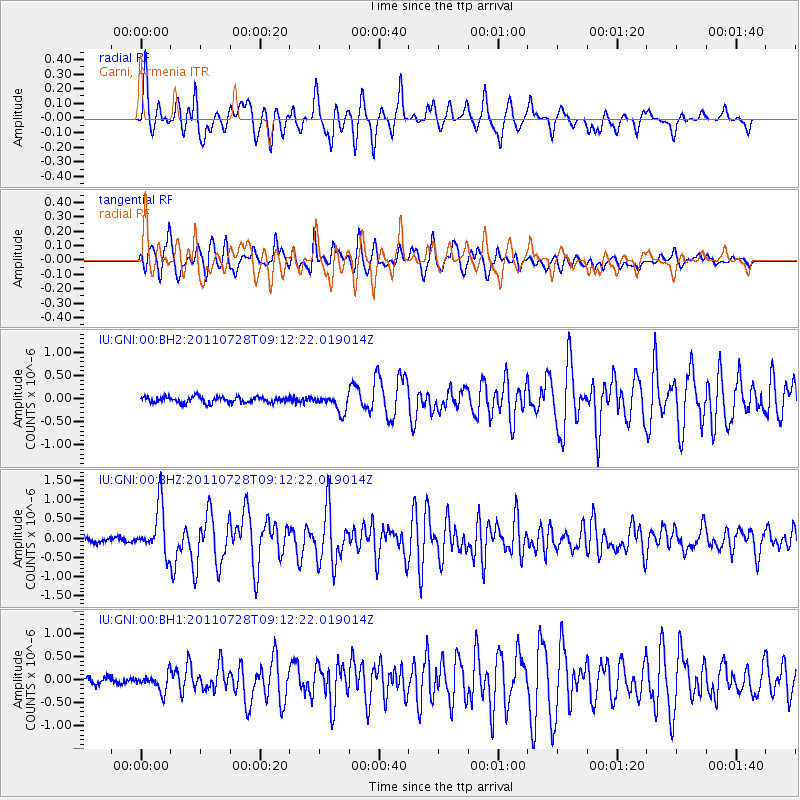
Signal To Noise
| Channel | StoN | STA | LTA |
| IU:GNI:00:BHZ:20110728T09:12:22.019014Z | 7.435925 | 6.309912E-7 | 8.485713E-8 |
| IU:GNI:00:BH1:20110728T09:12:22.019014Z | 2.2254727 | 1.9308689E-7 | 8.676219E-8 |
| IU:GNI:00:BH2:20110728T09:12:22.019014Z | 2.7747939 | 1.8218763E-7 | 6.565808E-8 |
| Arrivals |
| Ps | 9.3 SECOND |
| PpPs | 30 SECOND |
| PsPs/PpSs | 39 SECOND |


