You are here: Home > Network List > TA - USArray Transportable Network (new EarthScope stations) Stations List
> Station N60A Cedar Hill Farm, Mount Bethel, PA, USA > Earthquake Result Viewer
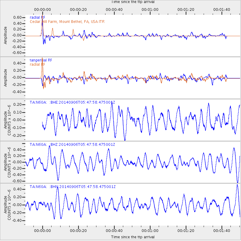
N60A Cedar Hill Farm, Mount Bethel, PA, USA - Earthquake Result Viewer
*The percent match for this event was below the threshold and hence no stack was calculated.
| Earthquake location: |
Iceland |
| Earthquake latitude/longitude: |
64.7/-17.5 |
| Earthquake time(UTC): |
2014/09/06 (249) 05:40:51 GMT |
| Earthquake Depth: |
3.7 km |
| Earthquake Magnitude: |
5.1 MW |
| Earthquake Catalog/Contributor: |
ISC/ISC |
|
| Network: |
TA USArray Transportable Network (new EarthScope stations) |
| Station: |
N60A Cedar Hill Farm, Mount Bethel, PA, USA |
| Lat/Lon: |
40.87 N/75.10 W |
| Elevation: |
189 m |
|
| Distance: |
40.3 deg |
| Az: |
262.316 deg |
| Baz: |
34.182 deg |
| Ray Param: |
$rayparam |
*The percent match for this event was below the threshold and hence was not used in the summary stack. |
|
| Radial Match: |
62.535397 % |
| Radial Bump: |
400 |
| Transverse Match: |
52.110836 % |
| Transverse Bump: |
400 |
| SOD ConfigId: |
3390531 |
| Insert Time: |
2019-04-13 21:20:22.475 +0000 |
| GWidth: |
2.5 |
| Max Bumps: |
400 |
| Tol: |
0.001 |
|
Signal To Noise
| Channel | StoN | STA | LTA |
| TA:N60A: :BHZ:20140906T05:47:58.475001Z | 2.1494453 | 2.569941E-7 | 1.19563E-7 |
| TA:N60A: :BHN:20140906T05:47:58.475001Z | 0.78540933 | 5.4295793E-8 | 6.9130564E-8 |
| TA:N60A: :BHE:20140906T05:47:58.475001Z | 1.171034 | 9.318752E-8 | 7.957713E-8 |
| Arrivals |
| Ps | |
| PpPs | |
| PsPs/PpSs | |


