You are here: Home > Network List > US - United States National Seismic Network Stations List
> Station MSO Missoula, Montana, USA > Earthquake Result Viewer
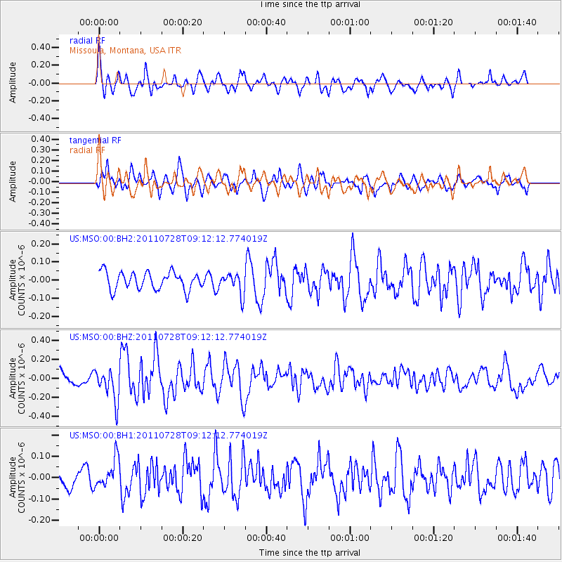
MSO Missoula, Montana, USA - Earthquake Result Viewer
*The percent match for this event was below the threshold and hence no stack was calculated.
| Earthquake location: |
Off East Coast Of Honshu, Japan |
| Earthquake latitude/longitude: |
40.3/143.2 |
| Earthquake time(UTC): |
2011/07/28 (209) 09:01:39 GMT |
| Earthquake Depth: |
31 km |
| Earthquake Magnitude: |
5.6 MW, 5.6 MW |
| Earthquake Catalog/Contributor: |
NEIC PDE/NEIC PDE-M |
|
| Network: |
US United States National Seismic Network |
| Station: |
MSO Missoula, Montana, USA |
| Lat/Lon: |
46.83 N/113.94 W |
| Elevation: |
1264 m |
|
| Distance: |
69.4 deg |
| Az: |
45.673 deg |
| Baz: |
307.22 deg |
| Ray Param: |
$rayparam |
*The percent match for this event was below the threshold and hence was not used in the summary stack. |
|
| Radial Match: |
74.349396 % |
| Radial Bump: |
400 |
| Transverse Match: |
81.431854 % |
| Transverse Bump: |
400 |
| SOD ConfigId: |
558545 |
| Insert Time: |
2013-09-18 23:42:58.218 +0000 |
| GWidth: |
2.5 |
| Max Bumps: |
400 |
| Tol: |
0.001 |
|
Signal To Noise
| Channel | StoN | STA | LTA |
| US:MSO:00:BHZ:20110728T09:12:12.774019Z | 2.2619376 | 1.7050347E-7 | 7.537938E-8 |
| US:MSO:00:BH1:20110728T09:12:12.774019Z | 1.4430555 | 6.843786E-8 | 4.7425665E-8 |
| US:MSO:00:BH2:20110728T09:12:12.774019Z | 1.2514079 | 6.061881E-8 | 4.8440487E-8 |
| Arrivals |
| Ps | |
| PpPs | |
| PsPs/PpSs | |


