You are here: Home > Network List > US - United States National Seismic Network Stations List
> Station DGMT Dagmar, Montana, USA > Earthquake Result Viewer
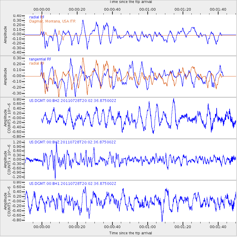
DGMT Dagmar, Montana, USA - Earthquake Result Viewer
*The percent match for this event was below the threshold and hence no stack was calculated.
| Earthquake location: |
Off Coast Of Central Chile |
| Earthquake latitude/longitude: |
-35.8/-73.1 |
| Earthquake time(UTC): |
2011/07/28 (209) 19:50:20 GMT |
| Earthquake Depth: |
35 km |
| Earthquake Magnitude: |
5.6 MW, 5.5 MB, 5.7 MW |
| Earthquake Catalog/Contributor: |
NEIC PDE/NEIC PDE-M |
|
| Network: |
US United States National Seismic Network |
| Station: |
DGMT Dagmar, Montana, USA |
| Lat/Lon: |
48.47 N/104.20 W |
| Elevation: |
0.0 m |
|
| Distance: |
88.3 deg |
| Az: |
339.898 deg |
| Baz: |
155.166 deg |
| Ray Param: |
$rayparam |
*The percent match for this event was below the threshold and hence was not used in the summary stack. |
|
| Radial Match: |
56.985962 % |
| Radial Bump: |
400 |
| Transverse Match: |
52.449833 % |
| Transverse Bump: |
400 |
| SOD ConfigId: |
558545 |
| Insert Time: |
2013-09-18 23:45:01.039 +0000 |
| GWidth: |
2.5 |
| Max Bumps: |
400 |
| Tol: |
0.001 |
|
Signal To Noise
| Channel | StoN | STA | LTA |
| US:DGMT:00:BHZ:20110728T20:02:36.875002Z | 2.869753 | 3.108521E-7 | 1.08320165E-7 |
| US:DGMT:00:BH1:20110728T20:02:36.875002Z | 0.9962541 | 1.7247886E-7 | 1.7312739E-7 |
| US:DGMT:00:BH2:20110728T20:02:36.875002Z | 1.3723872 | 2.560337E-7 | 1.8656084E-7 |
| Arrivals |
| Ps | |
| PpPs | |
| PsPs/PpSs | |


