You are here: Home > Network List > ER - Mount Erebus Volcano Observatory Seismic Network Stations List
> Station HOO Hoopers Shoulder,Mt Erebus Volcano Observatory Network, > Earthquake Result Viewer
HOO Hoopers Shoulder,Mt Erebus Volcano Observatory Network, - Earthquake Result Viewer
| Earthquake location: |
South Of Fiji Islands |
| Earthquake latitude/longitude: |
-23.8/179.8 |
| Earthquake time(UTC): |
2011/07/29 (210) 07:42:22 GMT |
| Earthquake Depth: |
523 km |
| Earthquake Magnitude: |
6.2 MB, 6.7 MW, 6.7 MW |
| Earthquake Catalog/Contributor: |
WHDF/NEIC |
|
| Network: |
ER Mount Erebus Volcano Observatory Seismic Network |
| Station: |
HOO Hoopers Shoulder,Mt Erebus Volcano Observatory Network, |
| Lat/Lon: |
77.53 S/166.93 E |
| Elevation: |
2069 m |
|
| Distance: |
54.2 deg |
| Az: |
183.412 deg |
| Baz: |
14.53 deg |
| Ray Param: |
0.06342838 |
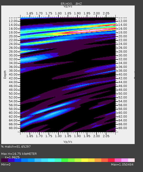
| Estimated Moho Depth: |
16.75 km |
| Estimated Crust Vp/Vs: |
1.96 |
| Assumed Crust Vp: |
6.183 km/s |
| Estimated Crust Vs: |
3.15 km/s |
| Estimated Crust Poisson's Ratio: |
0.32 |
|
| Radial Match: |
81.65297 % |
| Radial Bump: |
400 |
| Transverse Match: |
75.222565 % |
| Transverse Bump: |
400 |
| SOD ConfigId: |
558545 |
| Insert Time: |
2013-09-18 23:46:34.196 +0000 |
| GWidth: |
2.5 |
| Max Bumps: |
400 |
| Tol: |
0.001 |
|

Signal To Noise
| Channel | StoN | STA | LTA |
| ER:HOO: :BHZ:20110729T07:50:27.725001Z | 18.569794 | 4.485398E-6 | 2.415427E-7 |
| ER:HOO: :BH1:20110729T07:50:27.725001Z | 4.2431974 | 1.1188338E-6 | 2.6367704E-7 |
| ER:HOO: :BH2:20110729T07:50:27.725001Z | 7.9371943 | 2.0169998E-6 | 2.5412E-7 |
| Arrivals |
| Ps | 2.7 SECOND |
| PpPs | 7.7 SECOND |
| PsPs/PpSs | 10 SECOND |


