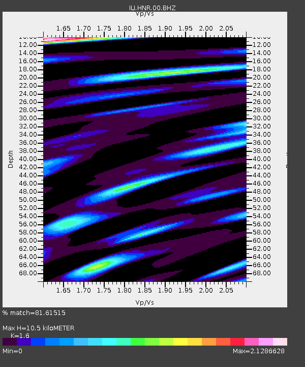
HNR Honiara, Solomon Islands - Earthquake Result Viewer
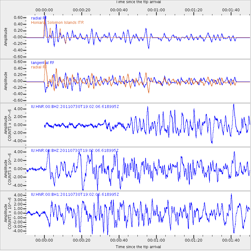
Earthquake location: Near East Coast Of Honshu, Japan
Earthquake latitude/longitude: 36.9/141.0
Earthquake time(UTC): 2011/07/30 (211) 18:53:49 GMT
Earthquake Depth: 30 km
Earthquake Magnitude: 6.4 MB, 6.0 MS, 6.5 MW, 6.4 MW
Earthquake Catalog/Contributor: WHDF/NEIC
Network: IU Global Seismograph Network (GSN - IRIS/USGS)
Station: HNR Honiara, Solomon Islands
Lat/Lon: 9.44 S/159.95 E
Elevation: 100 m
Distance: 49.5 deg
Az: 155.012 deg
Baz: 339.939 deg
Ray Param: 0.068631254
Estimated Moho Depth: 10.5 km
Estimated Crust Vp/Vs: 1.60
Assumed Crust Vp: 6.183 km/s
Estimated Crust Vs: 3.864 km/s
Estimated Crust Poisson's Ratio: 0.18
Radial Match: 81.61515 %
Radial Bump: 400
Transverse Match: 78.32981 %
Transverse Bump: 400
SOD ConfigId: 558545
Insert Time: 2013-09-18 23:51:42.322 +0000
GWidth: 2.5
Max Bumps: 400
Tol: 0.001

Signal To Noise

ChannelStoNSTALTA
IU:HNR:00:BHZ:20110730T19:02:06.618995Z7.35869931.9870736E-62.7003054E-7
IU:HNR:00:BH1:20110730T19:02:06.618995Z5.5176981.3993563E-62.5361234E-7
IU:HNR:00:BH2:20110730T19:02:06.618995Z1.92732755.546932E-72.8780434E-7
Arrivals
Ps1.1 SECOND
PpPs4.2 SECOND
PsPs/PpSs5.2 SECOND