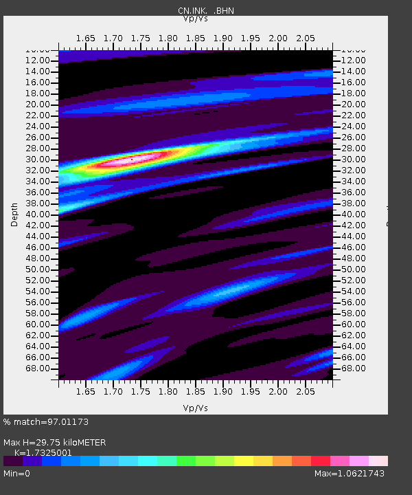
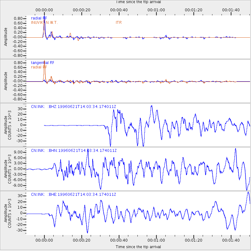
INK INUVIK, N.W.T. - Earthquake Result Viewer

Earthquake location: Off East Coast Of Kamchatka
Earthquake latitude/longitude: 51.6/159.1
Earthquake time(UTC): 1996/06/21 (173) 13:57:10 GMT
Earthquake Depth: 20 km
Earthquake Magnitude: 6.0 MB, 6.6 MS, 7.0 UNKNOWN, 6.5 MS
Earthquake Catalog/Contributor: WHDF/NEIC
Network: CN Canadian National Seismograph Network
Station: INK INUVIK, N.W.T.
Lat/Lon: 68.31 N/133.52 W
Elevation: 40 m
Distance: 35.4 deg
Az: 36.273 deg
Baz: 276.679 deg
Ray Param: 0.07719276
Estimated Moho Depth: 29.75 km
Estimated Crust Vp/Vs: 1.73
Assumed Crust Vp: 6.171 km/s
Estimated Crust Vs: 3.562 km/s
Estimated Crust Poisson's Ratio: 0.25
Radial Match: 97.01173 %
Radial Bump: 202
Transverse Match: 84.53121 %
Transverse Bump: 400
SOD ConfigId: 6273
Insert Time: 2010-02-27 06:15:30.073 +0000
GWidth: 2.5
Max Bumps: 400
Tol: 0.001

Signal To Noise

ChannelStoNSTALTA
CN:INK: :BHN:19960621T14:03:34.174011Z2.5311368370.40488146.33932
CN:INK: :BHE:19960621T14:03:34.174011Z19.6426982580.0908131.35115
CN:INK: :BHZ:19960621T14:03:34.174011Z23.6654155219.699220.56233
Arrivals
Ps3.8 SECOND
PpPs12 SECOND
PsPs/PpSs16 SECOND