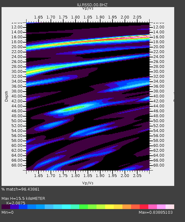
RSSD Black Hills, South Dakota, USA - Earthquake Result Viewer
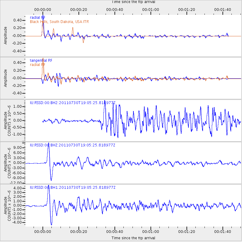
Earthquake location: Near East Coast Of Honshu, Japan
Earthquake latitude/longitude: 36.9/141.0
Earthquake time(UTC): 2011/07/30 (211) 18:53:49 GMT
Earthquake Depth: 30 km
Earthquake Magnitude: 6.4 MB, 6.0 MS, 6.5 MW, 6.4 MW
Earthquake Catalog/Contributor: WHDF/NEIC
Network: IU Global Seismograph Network (GSN - IRIS/USGS)
Station: RSSD Black Hills, South Dakota, USA
Lat/Lon: 44.12 N/104.04 W
Elevation: 2090 m
Distance: 80.1 deg
Az: 41.49 deg
Baz: 312.527 deg
Ray Param: 0.048443016
Estimated Moho Depth: 15.5 km
Estimated Crust Vp/Vs: 2.09
Assumed Crust Vp: 6.242 km/s
Estimated Crust Vs: 2.99 km/s
Estimated Crust Poisson's Ratio: 0.35
Radial Match: 96.43861 %
Radial Bump: 310
Transverse Match: 91.40813 %
Transverse Bump: 400
SOD ConfigId: 558545
Insert Time: 2013-09-18 23:52:13.158 +0000
GWidth: 2.5
Max Bumps: 400
Tol: 0.001

Signal To Noise

ChannelStoNSTALTA
IU:RSSD:00:BHZ:20110730T19:05:25.818977Z87.4937745.452726E-66.23213E-8
IU:RSSD:00:BH1:20110730T19:05:25.818977Z24.95622.2619206E-69.0635616E-8
IU:RSSD:00:BH2:20110730T19:05:25.818977Z7.1556714.668023E-76.523529E-8
Arrivals
Ps2.8 SECOND
PpPs7.5 SECOND
PsPs/PpSs10 SECOND