You are here: Home > Network List > KZ - Kazakhstan Network Stations List
> Station KUR21 Cross-array, Kurchatov, Kazakstan > Earthquake Result Viewer
KUR21 Cross-array, Kurchatov, Kazakstan - Earthquake Result Viewer
| Earthquake location: |
Near East Coast Of Honshu, Japan |
| Earthquake latitude/longitude: |
36.9/141.0 |
| Earthquake time(UTC): |
2011/07/30 (211) 18:53:49 GMT |
| Earthquake Depth: |
30 km |
| Earthquake Magnitude: |
6.4 MB, 6.0 MS, 6.5 MW, 6.4 MW |
| Earthquake Catalog/Contributor: |
WHDF/NEIC |
|
| Network: |
KZ Kazakhstan Network |
| Station: |
KUR21 Cross-array, Kurchatov, Kazakstan |
| Lat/Lon: |
50.62 N/78.53 E |
| Elevation: |
200 m |
|
| Distance: |
45.8 deg |
| Az: |
308.002 deg |
| Baz: |
82.355 deg |
| Ray Param: |
0.07100356 |
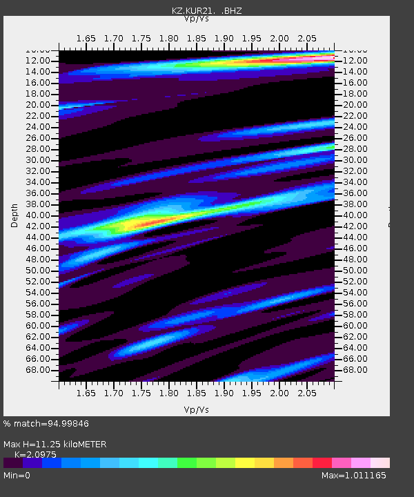
| Estimated Moho Depth: |
11.25 km |
| Estimated Crust Vp/Vs: |
2.10 |
| Assumed Crust Vp: |
6.552 km/s |
| Estimated Crust Vs: |
3.124 km/s |
| Estimated Crust Poisson's Ratio: |
0.35 |
|
| Radial Match: |
94.99846 % |
| Radial Bump: |
400 |
| Transverse Match: |
95.20659 % |
| Transverse Bump: |
377 |
| SOD ConfigId: |
558545 |
| Insert Time: |
2013-09-18 23:52:26.356 +0000 |
| GWidth: |
2.5 |
| Max Bumps: |
400 |
| Tol: |
0.001 |
|

Signal To Noise
| Channel | StoN | STA | LTA |
| KZ:KUR21: :BHZ:20110730T19:01:38.000007Z | 71.88662 | 2.8446018E-6 | 3.957067E-8 |
| KZ:KUR21: :BH1:20110730T19:01:38.000007Z | 43.856873 | 1.4145933E-6 | 3.2254768E-8 |
| KZ:KUR21: :BH2:20110730T19:01:38.000007Z | 6.4214005 | 2.2437229E-7 | 3.4941333E-8 |
| Arrivals |
| Ps | 2.0 SECOND |
| PpPs | 5.0 SECOND |
| PsPs/PpSs | 7.0 SECOND |


