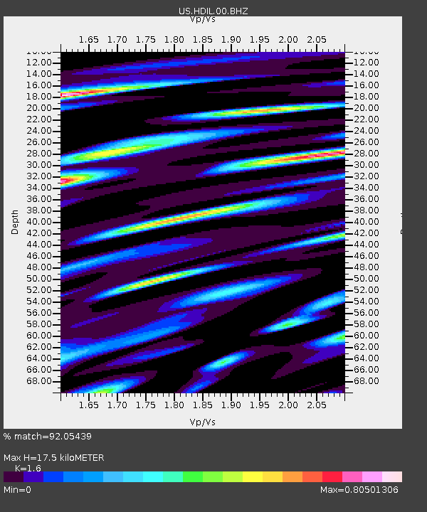
HDIL Hopedale, Illinois, USA - Earthquake Result Viewer
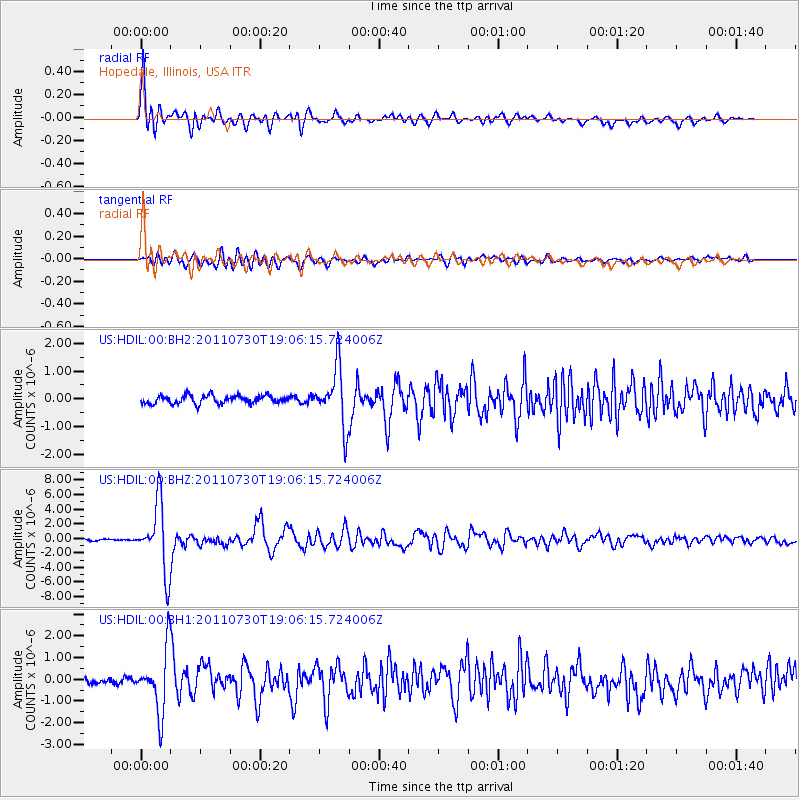
Earthquake location: Near East Coast Of Honshu, Japan
Earthquake latitude/longitude: 36.9/141.0
Earthquake time(UTC): 2011/07/30 (211) 18:53:49 GMT
Earthquake Depth: 30 km
Earthquake Magnitude: 6.4 MB, 6.0 MS, 6.5 MW, 6.4 MW
Earthquake Catalog/Contributor: WHDF/NEIC
Network: US United States National Seismic Network
Station: HDIL Hopedale, Illinois, USA
Lat/Lon: 40.56 N/89.29 W
Elevation: 219 m
Distance: 90.2 deg
Az: 35.861 deg
Baz: 321.975 deg
Ray Param: 0.04169009
Estimated Moho Depth: 17.5 km
Estimated Crust Vp/Vs: 1.60
Assumed Crust Vp: 6.498 km/s
Estimated Crust Vs: 4.061 km/s
Estimated Crust Poisson's Ratio: 0.18
Radial Match: 92.05439 %
Radial Bump: 400
Transverse Match: 86.18839 %
Transverse Bump: 400
SOD ConfigId: 558545
Insert Time: 2013-09-18 23:53:24.314 +0000
GWidth: 2.5
Max Bumps: 400
Tol: 0.001

Signal To Noise

ChannelStoNSTALTA
US:HDIL:00:BHZ:20110730T19:06:15.724006Z38.079734.650445E-61.221239E-7
US:HDIL:00:BH1:20110730T19:06:15.724006Z7.05026771.4401026E-62.0426211E-7
US:HDIL:00:BH2:20110730T19:06:15.724006Z7.15473461.0422233E-61.4566903E-7
Arrivals
Ps1.7 SECOND
PpPs6.8 SECOND
PsPs/PpSs8.5 SECOND