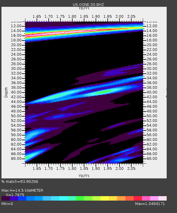
OGNE Ogallala, Nebraska, USA - Earthquake Result Viewer
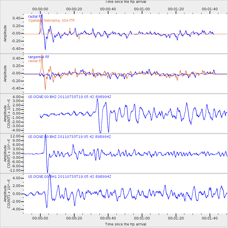
Earthquake location: Near East Coast Of Honshu, Japan
Earthquake latitude/longitude: 36.9/141.0
Earthquake time(UTC): 2011/07/30 (211) 18:53:49 GMT
Earthquake Depth: 30 km
Earthquake Magnitude: 6.4 MB, 6.0 MS, 6.5 MW, 6.4 MW
Earthquake Catalog/Contributor: WHDF/NEIC
Network: US United States National Seismic Network
Station: OGNE Ogallala, Nebraska, USA
Lat/Lon: 40.95 N/102.03 W
Elevation: 0.0 m
Distance: 83.4 deg
Az: 42.798 deg
Baz: 314.064 deg
Ray Param: 0.046182934
Estimated Moho Depth: 14.5 km
Estimated Crust Vp/Vs: 1.77
Assumed Crust Vp: 6.483 km/s
Estimated Crust Vs: 3.668 km/s
Estimated Crust Poisson's Ratio: 0.26
Radial Match: 93.98286 %
Radial Bump: 329
Transverse Match: 83.76212 %
Transverse Bump: 386
SOD ConfigId: 558545
Insert Time: 2013-09-18 23:54:11.676 +0000
GWidth: 2.5
Max Bumps: 400
Tol: 0.001

Signal To Noise

ChannelStoNSTALTA
US:OGNE:00:BHZ:20110730T19:05:42.898994Z56.6529356.508719E-61.14887584E-7
US:OGNE:00:BH1:20110730T19:05:42.898994Z3.78093771.3227965E-63.4985936E-7
US:OGNE:00:BH2:20110730T19:05:42.898994Z5.0936041.4241832E-62.7960226E-7
Arrivals
Ps1.8 SECOND
PpPs6.0 SECOND
PsPs/PpSs7.8 SECOND