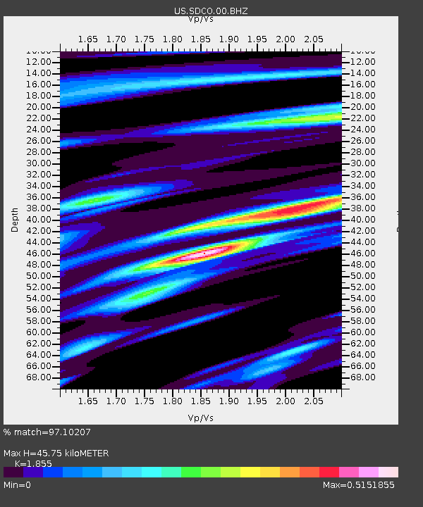
SDCO Great Sand Dunes National Park, Colorado, USA - Earthquake Result Viewer

Earthquake location: Near East Coast Of Honshu, Japan
Earthquake latitude/longitude: 36.9/141.0
Earthquake time(UTC): 2011/07/30 (211) 18:53:49 GMT
Earthquake Depth: 30 km
Earthquake Magnitude: 6.4 MB, 6.0 MS, 6.5 MW, 6.4 MW
Earthquake Catalog/Contributor: WHDF/NEIC
Network: US United States National Seismic Network
Station: SDCO Great Sand Dunes National Park, Colorado, USA
Lat/Lon: 37.75 N/105.50 W
Elevation: 2569 m
Distance: 83.6 deg
Az: 46.994 deg
Baz: 312.347 deg
Ray Param: 0.046021674
Estimated Moho Depth: 45.75 km
Estimated Crust Vp/Vs: 1.86
Assumed Crust Vp: 6.316 km/s
Estimated Crust Vs: 3.405 km/s
Estimated Crust Poisson's Ratio: 0.30
Radial Match: 97.10207 %
Radial Bump: 249
Transverse Match: 94.35856 %
Transverse Bump: 400
SOD ConfigId: 558545
Insert Time: 2013-09-18 23:54:25.145 +0000
GWidth: 2.5
Max Bumps: 400
Tol: 0.001

Signal To Noise

ChannelStoNSTALTA
US:SDCO:00:BHZ:20110730T19:05:44.049995Z70.689224.006189E-65.667327E-8
US:SDCO:00:BH1:20110730T19:05:44.049995Z15.3269225.612059E-73.6615695E-8
US:SDCO:00:BH2:20110730T19:05:44.049995Z17.9297711.2950265E-67.222772E-8
Arrivals
Ps6.3 SECOND
PpPs20 SECOND
PsPs/PpSs27 SECOND