WUAZ Wupatki, Arizona, USA - Earthquake Result Viewer
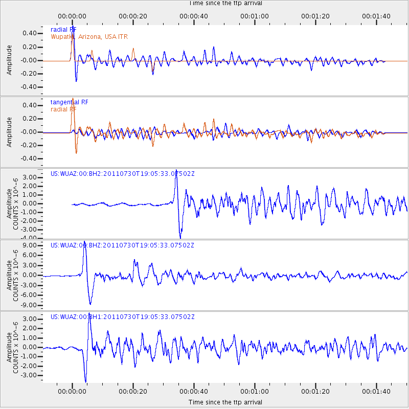
Earthquake location: Near East Coast Of Honshu, Japan
Earthquake latitude/longitude: 36.9/141.0
Earthquake time(UTC): 2011/07/30 (211) 18:53:49 GMT
Earthquake Depth: 30 km
Earthquake Magnitude: 6.4 MB, 6.0 MS, 6.5 MW, 6.4 MW
Earthquake Catalog/Contributor: WHDF/NEIC
Network: US United States National Seismic Network
Station: WUAZ Wupatki, Arizona, USA
Lat/Lon: 35.52 N/111.37 W
Elevation: 1592 m
Distance: 81.5 deg
Az: 51.807 deg
Baz: 309.479 deg
Ray Param: 0.047502186
Estimated Moho Depth: 48.25 km
Estimated Crust Vp/Vs: 1.73
Assumed Crust Vp: 6.207 km/s
Estimated Crust Vs: 3.583 km/s
Estimated Crust Poisson's Ratio: 0.25
Radial Match: 94.92755 %
Radial Bump: 400
Transverse Match: 83.900246 %
Transverse Bump: 400
SOD ConfigId: 558545
Insert Time: 2013-09-18 23:54:41.431 +0000
GWidth: 2.5
Max Bumps: 400
Tol: 0.001

Signal To Noise

ChannelStoNSTALTA
US:WUAZ:00:BHZ:20110730T19:05:33.07502Z60.343963.8321095E-66.3504444E-8
US:WUAZ:00:BH1:20110730T19:05:33.07502Z13.27837851.2398274E-69.33719E-8
US:WUAZ:00:BH2:20110730T19:05:33.07502Z13.6243261.30739E-69.5959976E-8
Arrivals
Ps5.8 SECOND
PpPs21 SECOND
PsPs/PpSs27 SECOND