You are here: Home > Network List > US - United States National Seismic Network Stations List
> Station MSO Missoula, Montana, USA > Earthquake Result Viewer
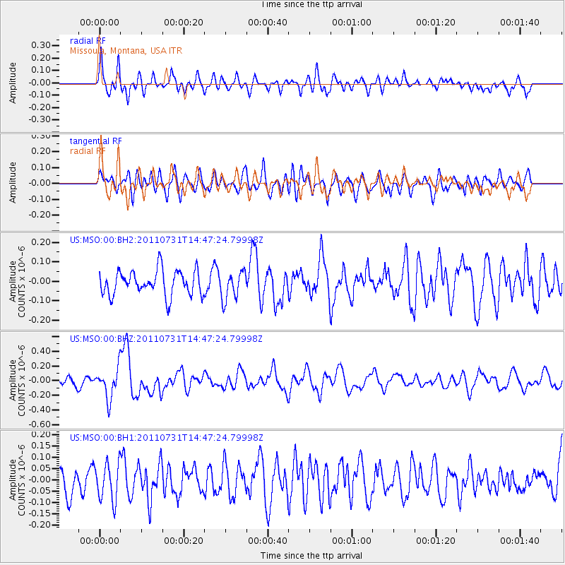
MSO Missoula, Montana, USA - Earthquake Result Viewer
*The percent match for this event was below the threshold and hence no stack was calculated.
| Earthquake location: |
Vanuatu Islands Region |
| Earthquake latitude/longitude: |
-17.0/171.6 |
| Earthquake time(UTC): |
2011/07/31 (212) 14:34:47 GMT |
| Earthquake Depth: |
10 km |
| Earthquake Magnitude: |
5.8 MB, 5.7 MS, 6.2 MW, 6.1 MW |
| Earthquake Catalog/Contributor: |
WHDF/NEIC |
|
| Network: |
US United States National Seismic Network |
| Station: |
MSO Missoula, Montana, USA |
| Lat/Lon: |
46.83 N/113.94 W |
| Elevation: |
1264 m |
|
| Distance: |
92.0 deg |
| Az: |
41.453 deg |
| Baz: |
247.29 deg |
| Ray Param: |
$rayparam |
*The percent match for this event was below the threshold and hence was not used in the summary stack. |
|
| Radial Match: |
58.238464 % |
| Radial Bump: |
400 |
| Transverse Match: |
49.61817 % |
| Transverse Bump: |
400 |
| SOD ConfigId: |
558545 |
| Insert Time: |
2013-09-18 23:56:46.975 +0000 |
| GWidth: |
2.5 |
| Max Bumps: |
400 |
| Tol: |
0.001 |
|
Signal To Noise
| Channel | StoN | STA | LTA |
| US:MSO:00:BHZ:20110731T14:47:24.79998Z | 3.0198278 | 2.1206486E-7 | 7.022416E-8 |
| US:MSO:00:BH1:20110731T14:47:24.79998Z | 1.5116769 | 8.25073E-8 | 5.4579985E-8 |
| US:MSO:00:BH2:20110731T14:47:24.79998Z | 1.1731981 | 7.417985E-8 | 6.3228754E-8 |
| Arrivals |
| Ps | |
| PpPs | |
| PsPs/PpSs | |


