You are here: Home > Network List > CN - Canadian National Seismograph Network Stations List
> Station INK INUVIK, N.W.T. > Earthquake Result Viewer
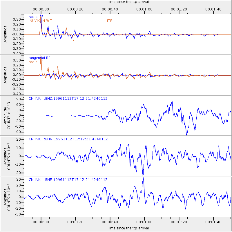
INK INUVIK, N.W.T. - Earthquake Result Viewer

| Earthquake location: |
Near Coast Of Peru |
| Earthquake latitude/longitude: |
-15.0/-75.7 |
| Earthquake time(UTC): |
1996/11/12 (317) 16:59:44 GMT |
| Earthquake Depth: |
33 km |
| Earthquake Magnitude: |
6.5 MB, 7.3 MS, 7.7 UNKNOWN, 7.7 MW |
| Earthquake Catalog/Contributor: |
WHDF/NEIC |
|
| Network: |
CN Canadian National Seismograph Network |
| Station: |
INK INUVIK, N.W.T. |
| Lat/Lon: |
68.31 N/133.52 W |
| Elevation: |
40 m |
|
| Distance: |
92.7 deg |
| Az: |
341.632 deg |
| Baz: |
125.007 deg |
| Ray Param: |
0.041391976 |
| Estimated Moho Depth: |
27.5 km |
| Estimated Crust Vp/Vs: |
1.90 |
| Assumed Crust Vp: |
6.171 km/s |
| Estimated Crust Vs: |
3.248 km/s |
| Estimated Crust Poisson's Ratio: |
0.31 |
|
| Radial Match: |
96.39025 % |
| Radial Bump: |
400 |
| Transverse Match: |
81.60012 % |
| Transverse Bump: |
400 |
| SOD ConfigId: |
6273 |
| Insert Time: |
2010-02-27 06:15:54.032 +0000 |
| GWidth: |
2.5 |
| Max Bumps: |
400 |
| Tol: |
0.001 |
|
Signal To Noise
| Channel | StoN | STA | LTA |
| CN:INK: :BHN:19961112T17:12:21.424011Z | 1.5143105 | 1178.2936 | 778.1057 |
| CN:INK: :BHE:19961112T17:12:21.424011Z | 1.604705 | 1801.1002 | 1122.3871 |
| CN:INK: :BHZ:19961112T17:12:21.424011Z | 3.5296745 | 4026.8914 | 1140.8677 |
| Arrivals |
| Ps | 4.1 SECOND |
| PpPs | 13 SECOND |
| PsPs/PpSs | 17 SECOND |


