You are here: Home > Network List > US - United States National Seismic Network Stations List
> Station MSO Missoula, Montana, USA > Earthquake Result Viewer
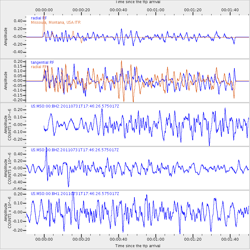
MSO Missoula, Montana, USA - Earthquake Result Viewer
*The percent match for this event was below the threshold and hence no stack was calculated.
| Earthquake location: |
Hokkaido, Japan Region |
| Earthquake latitude/longitude: |
41.8/142.8 |
| Earthquake time(UTC): |
2011/07/31 (212) 17:35:57 GMT |
| Earthquake Depth: |
32 km |
| Earthquake Magnitude: |
5.5 MB |
| Earthquake Catalog/Contributor: |
NEIC PDE/NEIC PDE-M |
|
| Network: |
US United States National Seismic Network |
| Station: |
MSO Missoula, Montana, USA |
| Lat/Lon: |
46.83 N/113.94 W |
| Elevation: |
1264 m |
|
| Distance: |
68.6 deg |
| Az: |
45.887 deg |
| Baz: |
308.565 deg |
| Ray Param: |
$rayparam |
*The percent match for this event was below the threshold and hence was not used in the summary stack. |
|
| Radial Match: |
59.415695 % |
| Radial Bump: |
400 |
| Transverse Match: |
69.576805 % |
| Transverse Bump: |
400 |
| SOD ConfigId: |
558545 |
| Insert Time: |
2013-09-19 00:00:32.814 +0000 |
| GWidth: |
2.5 |
| Max Bumps: |
400 |
| Tol: |
0.001 |
|
Signal To Noise
| Channel | StoN | STA | LTA |
| US:MSO:00:BHZ:20110731T17:46:26.575017Z | 2.7966897 | 2.1295733E-7 | 7.6146215E-8 |
| US:MSO:00:BH1:20110731T17:46:26.575017Z | 1.3453128 | 6.955453E-8 | 5.1701377E-8 |
| US:MSO:00:BH2:20110731T17:46:26.575017Z | 1.6510925 | 9.918307E-8 | 6.007117E-8 |
| Arrivals |
| Ps | |
| PpPs | |
| PsPs/PpSs | |


