You are here: Home > Network List > US - United States National Seismic Network Stations List
> Station SCIA State Center, Iowa, USA > Earthquake Result Viewer
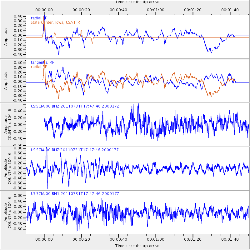
SCIA State Center, Iowa, USA - Earthquake Result Viewer
*The percent match for this event was below the threshold and hence no stack was calculated.
| Earthquake location: |
Hokkaido, Japan Region |
| Earthquake latitude/longitude: |
41.8/142.8 |
| Earthquake time(UTC): |
2011/07/31 (212) 17:35:57 GMT |
| Earthquake Depth: |
32 km |
| Earthquake Magnitude: |
5.5 MB |
| Earthquake Catalog/Contributor: |
NEIC PDE/NEIC PDE-M |
|
| Network: |
US United States National Seismic Network |
| Station: |
SCIA State Center, Iowa, USA |
| Lat/Lon: |
41.91 N/93.22 W |
| Elevation: |
312 m |
|
| Distance: |
82.5 deg |
| Az: |
38.641 deg |
| Baz: |
321.279 deg |
| Ray Param: |
$rayparam |
*The percent match for this event was below the threshold and hence was not used in the summary stack. |
|
| Radial Match: |
39.491093 % |
| Radial Bump: |
400 |
| Transverse Match: |
54.92376 % |
| Transverse Bump: |
400 |
| SOD ConfigId: |
558545 |
| Insert Time: |
2013-09-19 00:00:52.582 +0000 |
| GWidth: |
2.5 |
| Max Bumps: |
400 |
| Tol: |
0.001 |
|
Signal To Noise
| Channel | StoN | STA | LTA |
| US:SCIA:00:BHZ:20110731T17:47:46.200017Z | 2.7084959 | 3.3497332E-7 | 1.2367504E-7 |
| US:SCIA:00:BH1:20110731T17:47:46.200017Z | 1.0687469 | 1.6029246E-7 | 1.4998167E-7 |
| US:SCIA:00:BH2:20110731T17:47:46.200017Z | 1.2969153 | 1.7929823E-7 | 1.3824975E-7 |
| Arrivals |
| Ps | |
| PpPs | |
| PsPs/PpSs | |


