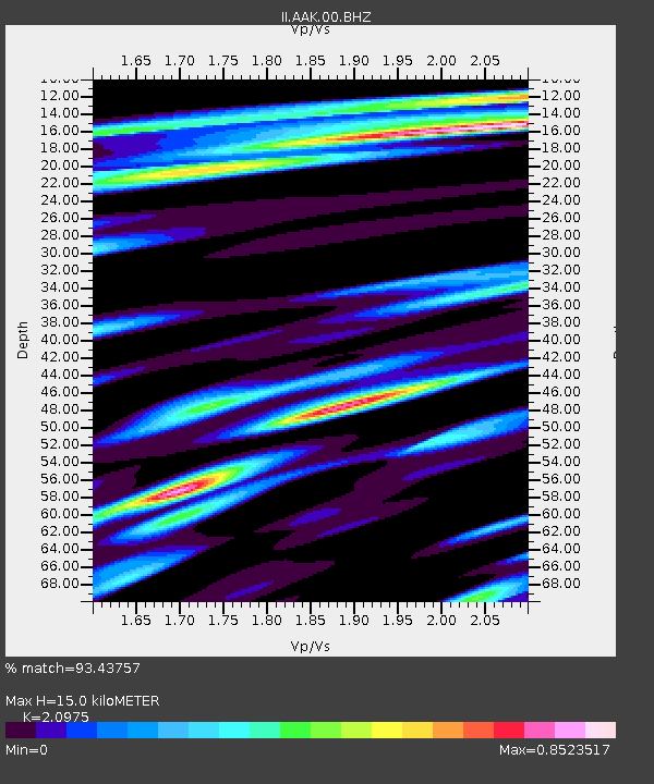
AAK Ala Archa, Kyrgyzstan - Earthquake Result Viewer

Earthquake location: Near N Coast Of New Guinea, P.N.G.
Earthquake latitude/longitude: -3.5/144.8
Earthquake time(UTC): 2011/07/31 (212) 23:38:56 GMT
Earthquake Depth: 10 km
Earthquake Magnitude: 6.2 MB, 6.6 MS, 6.6 MW, 6.6 MW
Earthquake Catalog/Contributor: WHDF/NEIC
Network: II Global Seismograph Network (GSN - IRIS/IDA)
Station: AAK Ala Archa, Kyrgyzstan
Lat/Lon: 42.64 N/74.49 E
Elevation: 1645 m
Distance: 78.1 deg
Az: 314.749 deg
Baz: 106.122 deg
Ray Param: 0.04989273
Estimated Moho Depth: 15.0 km
Estimated Crust Vp/Vs: 2.10
Assumed Crust Vp: 6.306 km/s
Estimated Crust Vs: 3.006 km/s
Estimated Crust Poisson's Ratio: 0.35
Radial Match: 93.43757 %
Radial Bump: 400
Transverse Match: 91.00181 %
Transverse Bump: 400
SOD ConfigId: 558545
Insert Time: 2013-09-19 00:01:44.217 +0000
GWidth: 2.5
Max Bumps: 400
Tol: 0.001

Signal To Noise

ChannelStoNSTALTA
II:AAK:00:BHZ:20110731T23:50:24.118972Z6.50480463.345708E-75.1434416E-8
II:AAK:00:BH1:20110731T23:50:24.118972Z0.935343272.4844804E-82.656223E-8
II:AAK:00:BH2:20110731T23:50:24.118972Z5.1499561.203197E-72.3363246E-8
Arrivals
Ps2.7 SECOND
PpPs7.2 SECOND
PsPs/PpSs9.9 SECOND