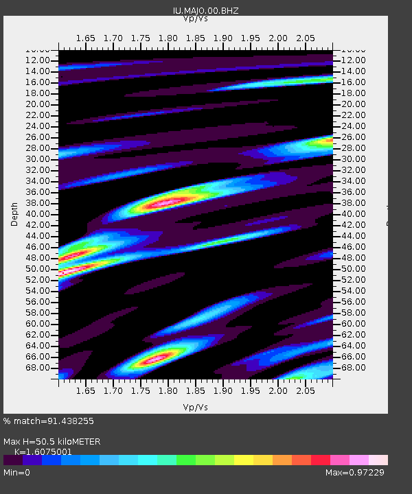
MAJO Matsushiro, Japan - Earthquake Result Viewer

Earthquake location: Near N Coast Of New Guinea, P.N.G.
Earthquake latitude/longitude: -3.5/144.8
Earthquake time(UTC): 2011/07/31 (212) 23:38:56 GMT
Earthquake Depth: 10 km
Earthquake Magnitude: 6.2 MB, 6.6 MS, 6.6 MW, 6.6 MW
Earthquake Catalog/Contributor: WHDF/NEIC
Network: IU Global Seismograph Network (GSN - IRIS/USGS)
Station: MAJO Matsushiro, Japan
Lat/Lon: 36.55 N/138.20 E
Elevation: 405 m
Distance: 40.3 deg
Az: 351.748 deg
Baz: 169.753 deg
Ray Param: 0.074458696
Estimated Moho Depth: 50.5 km
Estimated Crust Vp/Vs: 1.61
Assumed Crust Vp: 6.461 km/s
Estimated Crust Vs: 4.02 km/s
Estimated Crust Poisson's Ratio: 0.18
Radial Match: 91.438255 %
Radial Bump: 400
Transverse Match: 94.25161 %
Transverse Bump: 400
SOD ConfigId: 558545
Insert Time: 2013-09-19 00:02:20.319 +0000
GWidth: 2.5
Max Bumps: 400
Tol: 0.001

Signal To Noise

ChannelStoNSTALTA
IU:MAJO:00:BHZ:20110731T23:46:03.369003Z5.9579465.7005707E-79.568013E-8
IU:MAJO:00:BH1:20110731T23:46:03.369003Z5.8788123.6934057E-76.282572E-8
IU:MAJO:00:BH2:20110731T23:46:03.369003Z1.19565141.1632625E-79.729111E-8
Arrivals
Ps5.1 SECOND
PpPs19 SECOND
PsPs/PpSs24 SECOND