You are here: Home > Network List > US - United States National Seismic Network Stations List
> Station DGMT Dagmar, Montana, USA > Earthquake Result Viewer
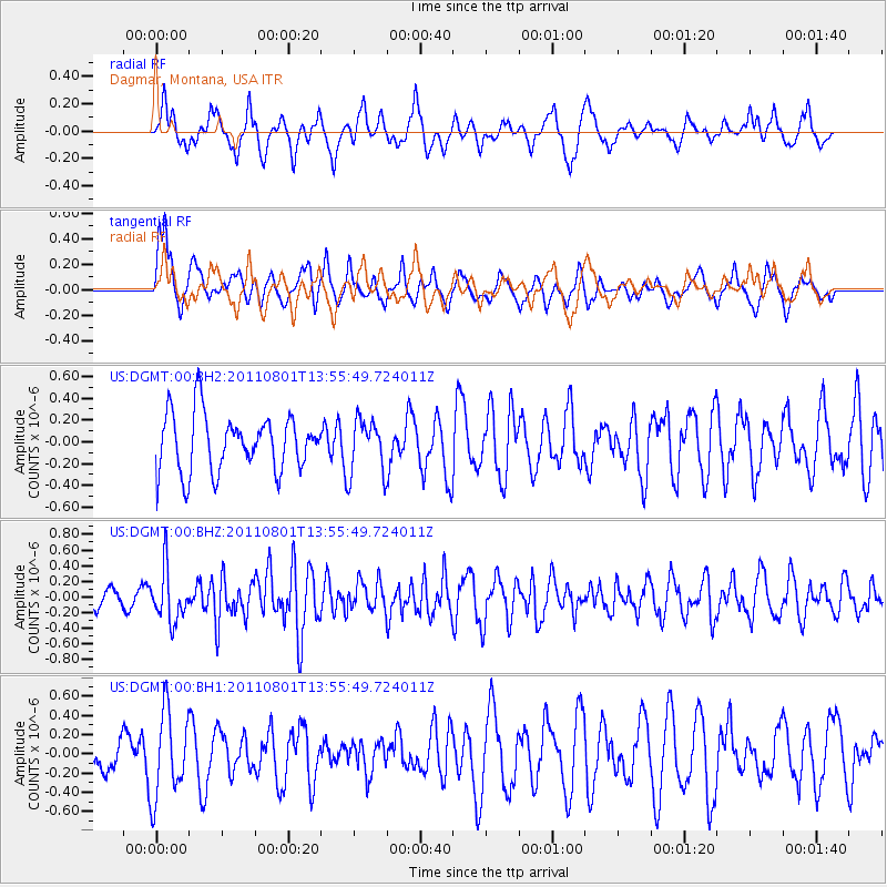
DGMT Dagmar, Montana, USA - Earthquake Result Viewer
*The percent match for this event was below the threshold and hence no stack was calculated.
| Earthquake location: |
Near East Coast Of Honshu, Japan |
| Earthquake latitude/longitude: |
39.8/142.1 |
| Earthquake time(UTC): |
2011/08/01 (213) 13:44:47 GMT |
| Earthquake Depth: |
40 km |
| Earthquake Magnitude: |
5.7 MW, 5.6 MB, 5.7 MW |
| Earthquake Catalog/Contributor: |
NEIC PDE/NEIC PDE-M |
|
| Network: |
US United States National Seismic Network |
| Station: |
DGMT Dagmar, Montana, USA |
| Lat/Lon: |
48.47 N/104.20 W |
| Elevation: |
0.0 m |
|
| Distance: |
74.3 deg |
| Az: |
39.257 deg |
| Baz: |
312.934 deg |
| Ray Param: |
$rayparam |
*The percent match for this event was below the threshold and hence was not used in the summary stack. |
|
| Radial Match: |
64.73215 % |
| Radial Bump: |
400 |
| Transverse Match: |
61.466347 % |
| Transverse Bump: |
400 |
| SOD ConfigId: |
558545 |
| Insert Time: |
2013-09-19 00:05:32.399 +0000 |
| GWidth: |
2.5 |
| Max Bumps: |
400 |
| Tol: |
0.001 |
|
Signal To Noise
| Channel | StoN | STA | LTA |
| US:DGMT:00:BHZ:20110801T13:55:49.724011Z | 1.9438725 | 3.3449774E-7 | 1.7207803E-7 |
| US:DGMT:00:BH1:20110801T13:55:49.724011Z | 2.160092 | 4.510582E-7 | 2.0881436E-7 |
| US:DGMT:00:BH2:20110801T13:55:49.724011Z | 0.94868696 | 2.4964223E-7 | 2.6314498E-7 |
| Arrivals |
| Ps | |
| PpPs | |
| PsPs/PpSs | |


