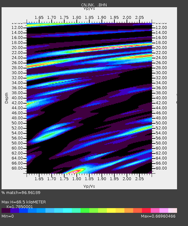
INK INUVIK, N.W.T. - Earthquake Result Viewer
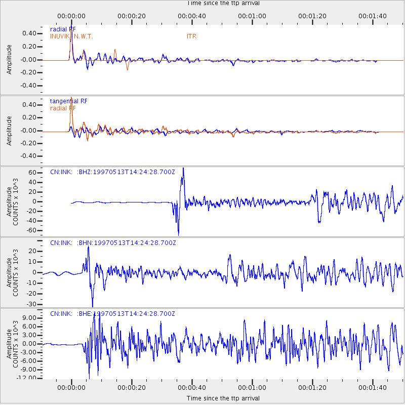
Earthquake location: Hindu Kush Region, Afghanistan
Earthquake latitude/longitude: 36.4/70.9
Earthquake time(UTC): 1997/05/13 (133) 14:13:45 GMT
Earthquake Depth: 196 km
Earthquake Magnitude: 6.1 MB, 6.5 UNKNOWN, 6.4 MW
Earthquake Catalog/Contributor: WHDF/NEIC
Network: CN Canadian National Seismograph Network
Station: INK INUVIK, N.W.T.
Lat/Lon: 68.31 N/133.52 W
Elevation: 40 m
Distance: 74.0 deg
Az: 9.217 deg
Baz: 339.663 deg
Ray Param: 0.052104037
Estimated Moho Depth: 69.5 km
Estimated Crust Vp/Vs: 1.79
Assumed Crust Vp: 6.171 km/s
Estimated Crust Vs: 3.457 km/s
Estimated Crust Poisson's Ratio: 0.27
Radial Match: 96.96189 %
Radial Bump: 306
Transverse Match: 87.357956 %
Transverse Bump: 400
SOD ConfigId: 6273
Insert Time: 2010-02-27 06:16:16.091 +0000
GWidth: 2.5
Max Bumps: 400
Tol: 0.001

Signal To Noise

ChannelStoNSTALTA
CN:INK: :BHN:19970513T14:24:28.700Z6.1804463521.6768569.80945
CN:INK: :BHE:19970513T14:24:28.700Z1.1438534802.4682701.5481
CN:INK: :BHZ:19970513T14:24:28.700Z11.988979383.809782.7035
Arrivals
Ps9.1 SECOND
PpPs30 SECOND
PsPs/PpSs40 SECOND