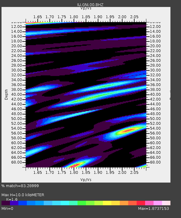
GNI Garni, Armenia - Earthquake Result Viewer
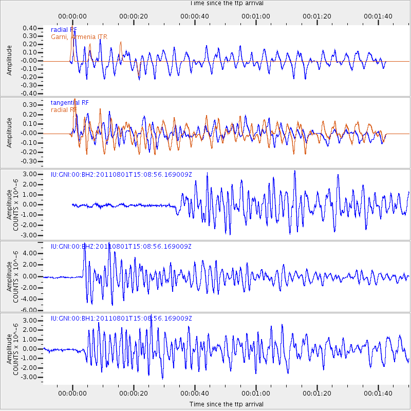
Earthquake location: Near S. Coast Of Honshu, Japan
Earthquake latitude/longitude: 34.6/138.4
Earthquake time(UTC): 2011/08/01 (213) 14:58:09 GMT
Earthquake Depth: 13 km
Earthquake Magnitude: 6.0 MB, 5.6 MS, 5.9 MW, 5.9 MW
Earthquake Catalog/Contributor: WHDF/NEIC
Network: IU Global Seismograph Network (GSN - IRIS/USGS)
Station: GNI Garni, Armenia
Lat/Lon: 40.15 N/44.74 E
Elevation: 1609 m
Distance: 71.2 deg
Az: 306.086 deg
Baz: 60.387 deg
Ray Param: 0.054488767
Estimated Moho Depth: 10.0 km
Estimated Crust Vp/Vs: 1.60
Assumed Crust Vp: 6.291 km/s
Estimated Crust Vs: 3.932 km/s
Estimated Crust Poisson's Ratio: 0.18
Radial Match: 83.28999 %
Radial Bump: 400
Transverse Match: 74.61495 %
Transverse Bump: 400
SOD ConfigId: 558545
Insert Time: 2013-09-19 00:08:11.169 +0000
GWidth: 2.5
Max Bumps: 400
Tol: 0.001

Signal To Noise

ChannelStoNSTALTA
IU:GNI:00:BHZ:20110801T15:08:56.169009Z20.0778221.9247539E-69.586467E-8
IU:GNI:00:BH1:20110801T15:08:56.169009Z3.86864833.4928718E-79.028662E-8
IU:GNI:00:BH2:20110801T15:08:56.169009Z3.7217053.415166E-79.1763475E-8
Arrivals
Ps1.0 SECOND
PpPs4.0 SECOND
PsPs/PpSs5.0 SECOND