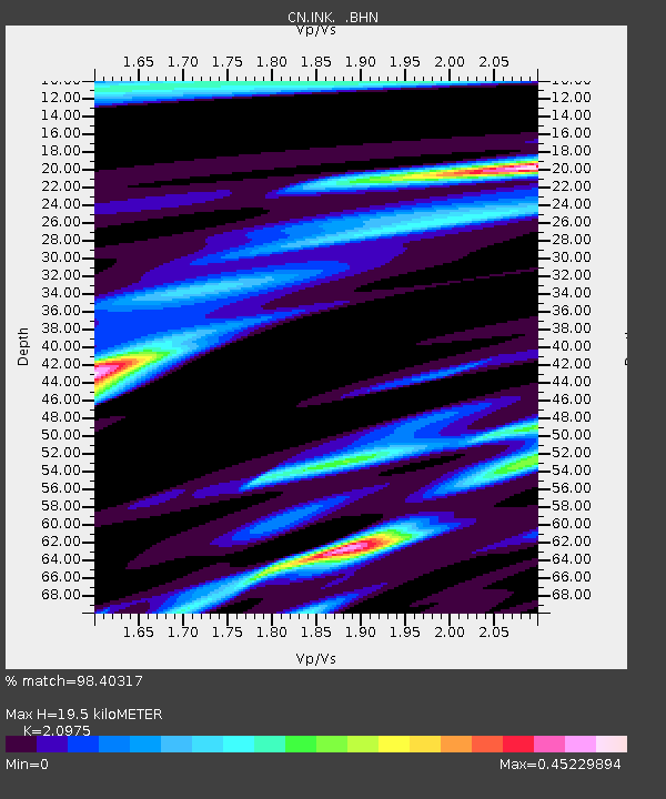
INK INUVIK, N.W.T. - Earthquake Result Viewer
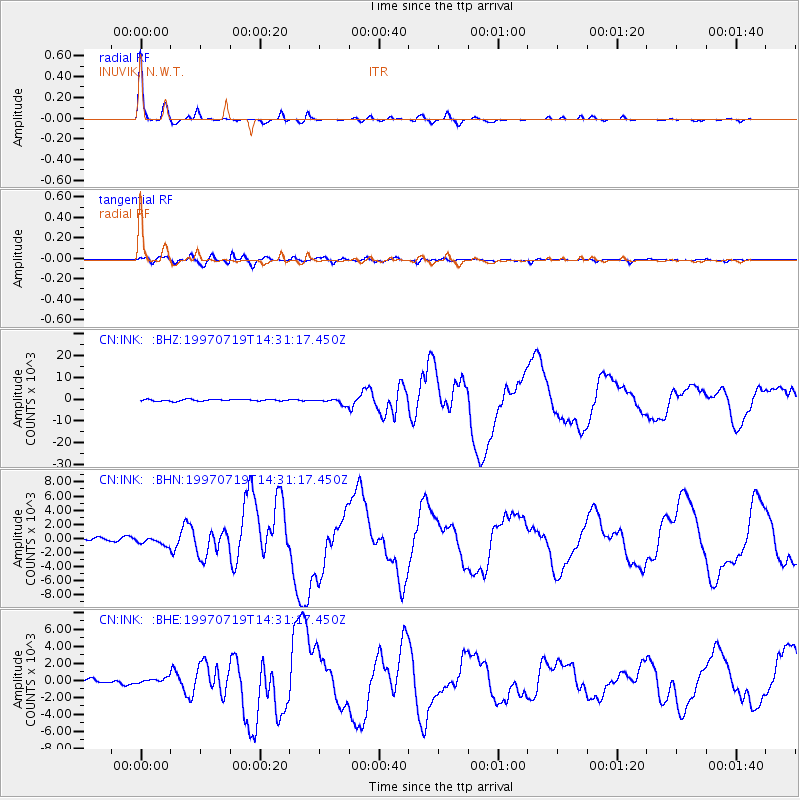
Earthquake location: Near Coast Of Guerrero, Mexico
Earthquake latitude/longitude: 16.3/-98.2
Earthquake time(UTC): 1997/07/19 (200) 14:22:08 GMT
Earthquake Depth: 33 km
Earthquake Magnitude: 5.7 MB, 6.3 MS, 6.8 UNKNOWN, 6.0 ME
Earthquake Catalog/Contributor: WHDF/NEIC
Network: CN Canadian National Seismograph Network
Station: INK INUVIK, N.W.T.
Lat/Lon: 68.31 N/133.52 W
Elevation: 40 m
Distance: 56.6 deg
Az: 345.083 deg
Baz: 138.332 deg
Ray Param: 0.06399026
Estimated Moho Depth: 19.5 km
Estimated Crust Vp/Vs: 2.10
Assumed Crust Vp: 6.171 km/s
Estimated Crust Vs: 2.942 km/s
Estimated Crust Poisson's Ratio: 0.35
Radial Match: 98.40317 %
Radial Bump: 263
Transverse Match: 86.35631 %
Transverse Bump: 400
SOD ConfigId: 6273
Insert Time: 2010-02-27 06:16:30.260 +0000
GWidth: 2.5
Max Bumps: 400
Tol: 0.001

Signal To Noise

ChannelStoNSTALTA
CN:INK: :BHN:19970719T14:31:17.450Z2.2945983556.5925242.56644
CN:INK: :BHE:19970719T14:31:17.450Z0.83174247281.85455338.87238
CN:INK: :BHZ:19970719T14:31:17.450Z3.50058461355.9358387.34555
Arrivals
Ps3.6 SECOND
PpPs9.4 SECOND
PsPs/PpSs13 SECOND