You are here: Home > Network List > US - United States National Seismic Network Stations List
> Station MSO Missoula, Montana, USA > Earthquake Result Viewer
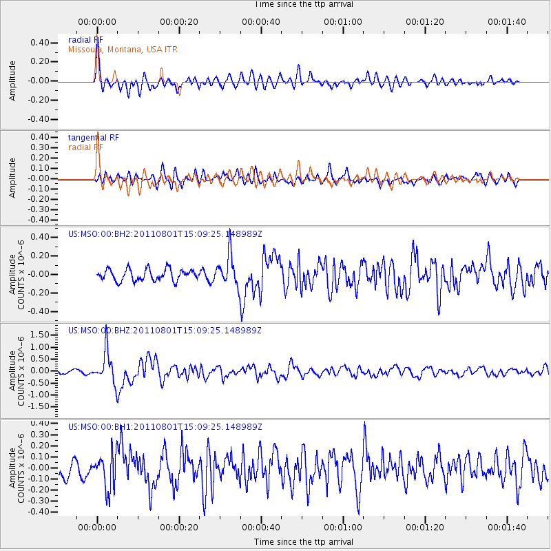
MSO Missoula, Montana, USA - Earthquake Result Viewer
*The percent match for this event was below the threshold and hence no stack was calculated.
| Earthquake location: |
Near S. Coast Of Honshu, Japan |
| Earthquake latitude/longitude: |
34.6/138.4 |
| Earthquake time(UTC): |
2011/08/01 (213) 14:58:09 GMT |
| Earthquake Depth: |
13 km |
| Earthquake Magnitude: |
6.0 MB, 5.6 MS, 5.9 MW, 5.9 MW |
| Earthquake Catalog/Contributor: |
WHDF/NEIC |
|
| Network: |
US United States National Seismic Network |
| Station: |
MSO Missoula, Montana, USA |
| Lat/Lon: |
46.83 N/113.94 W |
| Elevation: |
1264 m |
|
| Distance: |
76.1 deg |
| Az: |
42.381 deg |
| Baz: |
305.951 deg |
| Ray Param: |
$rayparam |
*The percent match for this event was below the threshold and hence was not used in the summary stack. |
|
| Radial Match: |
79.94824 % |
| Radial Bump: |
400 |
| Transverse Match: |
74.79172 % |
| Transverse Bump: |
400 |
| SOD ConfigId: |
558545 |
| Insert Time: |
2013-09-19 00:10:22.030 +0000 |
| GWidth: |
2.5 |
| Max Bumps: |
400 |
| Tol: |
0.001 |
|
Signal To Noise
| Channel | StoN | STA | LTA |
| US:MSO:00:BHZ:20110801T15:09:25.148989Z | 8.541945 | 6.961857E-7 | 8.1502E-8 |
| US:MSO:00:BH1:20110801T15:09:25.148989Z | 3.1583433 | 1.647152E-7 | 5.21524E-8 |
| US:MSO:00:BH2:20110801T15:09:25.148989Z | 2.8612735 | 1.7773739E-7 | 6.211828E-8 |
| Arrivals |
| Ps | |
| PpPs | |
| PsPs/PpSs | |


