You are here: Home > Network List > US - United States National Seismic Network Stations List
> Station BOZ Bozeman, Montana, USA > Earthquake Result Viewer
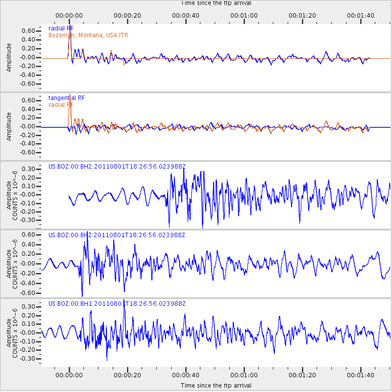
BOZ Bozeman, Montana, USA - Earthquake Result Viewer
*The percent match for this event was below the threshold and hence no stack was calculated.
| Earthquake location: |
Fox Islands, Aleutian Islands |
| Earthquake latitude/longitude: |
51.8/-171.3 |
| Earthquake time(UTC): |
2011/08/01 (213) 18:20:05 GMT |
| Earthquake Depth: |
41 km |
| Earthquake Magnitude: |
5.6 MW |
| Earthquake Catalog/Contributor: |
NEIC PDE/NEIC PDE-M |
|
| Network: |
US United States National Seismic Network |
| Station: |
BOZ Bozeman, Montana, USA |
| Lat/Lon: |
45.65 N/111.63 W |
| Elevation: |
1589 m |
|
| Distance: |
38.8 deg |
| Az: |
74.774 deg |
| Baz: |
301.316 deg |
| Ray Param: |
$rayparam |
*The percent match for this event was below the threshold and hence was not used in the summary stack. |
|
| Radial Match: |
75.20787 % |
| Radial Bump: |
400 |
| Transverse Match: |
43.505585 % |
| Transverse Bump: |
400 |
| SOD ConfigId: |
558545 |
| Insert Time: |
2013-09-19 00:13:25.924 +0000 |
| GWidth: |
2.5 |
| Max Bumps: |
400 |
| Tol: |
0.001 |
|
Signal To Noise
| Channel | StoN | STA | LTA |
| US:BOZ:00:BHZ:20110801T18:26:56.023988Z | 2.8886056 | 1.7966879E-7 | 6.219914E-8 |
| US:BOZ:00:BH1:20110801T18:26:56.023988Z | 1.9775827 | 8.06233E-8 | 4.076861E-8 |
| US:BOZ:00:BH2:20110801T18:26:56.023988Z | 2.0231893 | 9.038609E-8 | 4.467505E-8 |
| Arrivals |
| Ps | |
| PpPs | |
| PsPs/PpSs | |


