You are here: Home > Network List > CN - Canadian National Seismograph Network Stations List
> Station INK INUVIK, N.W.T. > Earthquake Result Viewer
INK INUVIK, N.W.T. - Earthquake Result Viewer
| Earthquake location: |
Fiji Islands Region |
| Earthquake latitude/longitude: |
-17.6/-179.1 |
| Earthquake time(UTC): |
1998/03/29 (088) 19:48:16 GMT |
| Earthquake Depth: |
537 km |
| Earthquake Magnitude: |
6.5 MB, 7.2 UNKNOWN, 7.1 MW |
| Earthquake Catalog/Contributor: |
WHDF/NEIC |
|
| Network: |
CN Canadian National Seismograph Network |
| Station: |
INK INUVIK, N.W.T. |
| Lat/Lon: |
68.31 N/133.52 W |
| Elevation: |
40 m |
|
| Distance: |
91.7 deg |
| Az: |
15.404 deg |
| Baz: |
222.969 deg |
| Ray Param: |
0.041207545 |
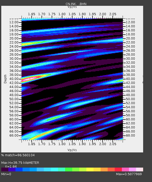
| Estimated Moho Depth: |
39.75 km |
| Estimated Crust Vp/Vs: |
1.64 |
| Assumed Crust Vp: |
6.171 km/s |
| Estimated Crust Vs: |
3.763 km/s |
| Estimated Crust Poisson's Ratio: |
0.20 |
|
| Radial Match: |
96.560104 % |
| Radial Bump: |
400 |
| Transverse Match: |
89.13073 % |
| Transverse Bump: |
400 |
| SOD ConfigId: |
6273 |
| Insert Time: |
2010-02-27 06:16:57.586 +0000 |
| GWidth: |
2.5 |
| Max Bumps: |
400 |
| Tol: |
0.001 |
|
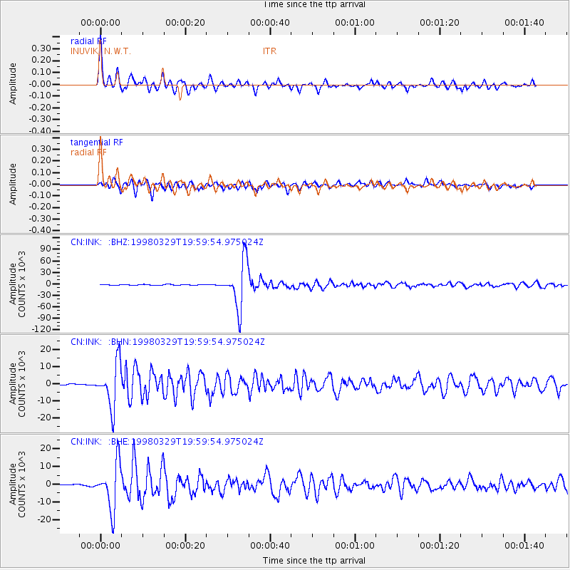
Signal To Noise
| Channel | StoN | STA | LTA |
| CN:INK: :BHN:19980329T19:59:54.975024Z | 34.06184 | 13362.18 | 392.29178 |
| CN:INK: :BHE:19980329T19:59:54.975024Z | 22.740828 | 13460.169 | 591.8944 |
| CN:INK: :BHZ:19980329T19:59:54.975024Z | 60.220036 | 62969.945 | 1045.6643 |
| Arrivals |
| Ps | 4.2 SECOND |
| PpPs | 17 SECOND |
| PsPs/PpSs | 21 SECOND |


